Monday, 16 September 2019


Indus River System: Jhelum, Chenab, Ravi, Beas & Satluj


Himalayan River Systems

  • The Indus, the Ganga and the Brahmaputra comprise the Himalayan river systems.
  • The Himalayan Rivers existed even before the formation of Himalayas i.e. before the collision of Indian Plate with the Eurasian plate. {Antecedent Drainage}
  • They were flowing into the Tethys Sea. These rivers had their source in the now Tibetan region.
  • The deep gorges of the Indus, the Satluj, the Brahmaputra etc. clearly indicate that these rivers are older than the Himalayas.
  • They continued to flow throughout the building phase of the Himalayas; their banks rising steeply while the beds went lower and lower due to vertical erosion (Vertical down cutting was significant and was occurring at a rate faster than the rising of Himalayas), thus cutting deep gorges.
  • Thus, many of the Himalayan Rivers are typical examples of antecedent drainage.

Indus River System

SindhuSanskrit
SinthosGreek
SindusLatin

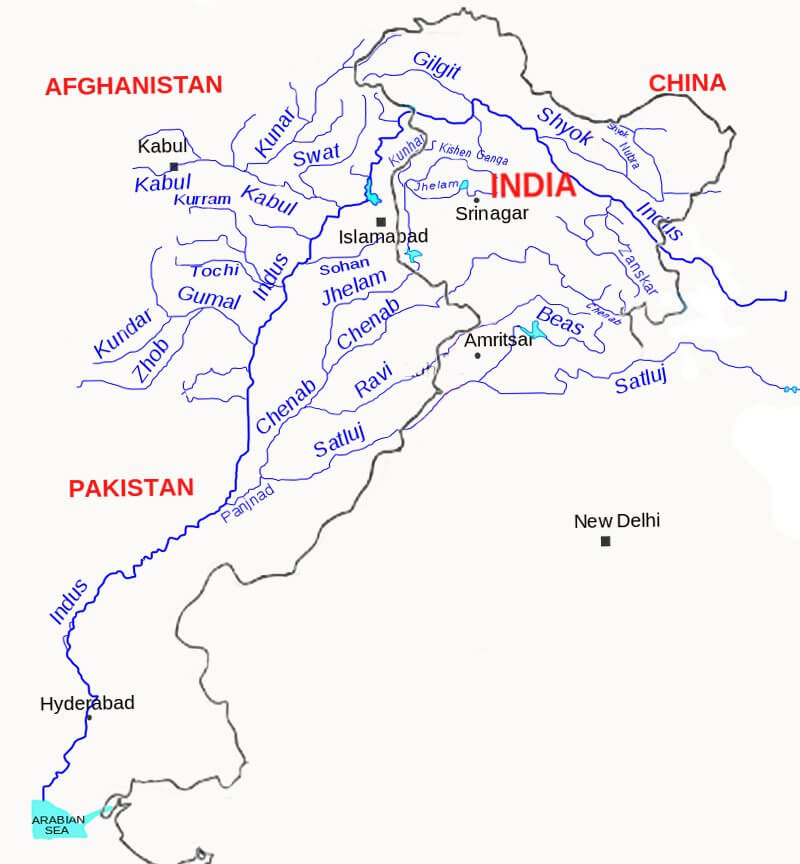
Major Rivers of Indus River System

Source

Length

IndusGlaciers of Kailas Range (Close to Manasarovar Lake)2880 km total.
710 km in India
JhelumVerinag720 km
ChenabBara Lacha Pass1180 km
RaviNear Rohtang Pass725 km
BeasNear Rohtang Pass460 km
SatlujManasarovar-Rakas Lakes
List of important passes given in previous posts
1450 km total
1050 km in India

Indus River

  • India got her name from Indus.
  • ‘The Indus Valley Civilization’ was born around this river.
  • It flows in north-west direction from its source (Glaciers of Kailas Range – Kailash range in Tibet near Lake Manasarovartill the Nanga Parbhat Range.
  • It’s length is about 2,900 km. Its total drainage area is about 1,165,000 square km [more than half of it lies in semiarid plains of Pakistan]. It is joined by Dhar River near Indo-China border.
  • After entering J&K it flows between the Ladakh and the Zaskar Ranges. It flows through the regions of Ladakh, Baltistan and Gilgit.
  • The gradient of the river in J&K is very gentle (about 30 cm per km).
  • Average elevation at which the Indus flows through JK is about 4000 m above sea level.
  • It is joined by the Zaskar River at Leh (these kind of points are important for prelims).
  • Near Skardu, it is joined by the Shyok at an elevation of about 2,700 m.
  • The Gilgit, Gartang, Dras, Shiger, Hunza are the other Himalayan tributaries of the Indus.
  • It crosses the Himalayas (ends its mountainous journey) through a 5181 m deep gorge near Attock, lying north of the Nanga Parbat. It takes a sharp southerly bend here (syntaxial bend).
  • Kabul river from Afghanistan joins Indus near Attock. Thereafter it flows through the Potwar plateau and crosses the Salt Range (South Eastern edge of Potwar Plateau).
  • Some of the important tributaries below Attock include the Kurram, Toch and the Zhob-Gomal.
  • Just above Mithankot, the Indus receives from Panjnad (Panchnad), the accumulated waters of the five eastern tributaries—the Jhelum, the Chenab, the Ravi, the Beas and the Satluj.
  • The river empties into the Arabian Sea south of Karachi after forming a huge delta.
Major Tributaries of Indus River

Major Tributaries of Indus River

Jhelum River

  • The Jhelum has its source in a spring at Verinag in the south-eastern part of the Kashmir Valley.
  • It flows northwards into Wular Lake (north-western part of Kashmir Valley). From Wular Lake, it changes its course southwards. At Baramulla the river enters a gorge in the hills.
  • The river forms steep-sided narrow gorge through Pir Panjal Range below Baramula.
  • At Muzaffarabad, the river takes a sharp hairpin bend southward.
  • Thereafter, it forms the India-Pakistan boundary for 170 km and emerges at the Potwar Plateau near Mirpur.
  • After flowing through the spurs of the Salt Range it debouches (emerge from a confined space into a wide, open area) on the plains near the city of Jhelum.
  • It joins the Chenab at Trimmu.
  • The river is navigable for about 160 km out of a total length of 724 km.

Chenab River

  • The Chenab originates from near the Bara Lacha Pass in the Lahul-Spiti part of the Zaskar Range.
  • Two small streams on opposite sides of the pass, namely Chandra and Bhaga, form its headwaters at an altitude of 4,900 m.
  • The united stream Chandrabhaga flows in the north-west direction through the Pangi valley, parallel to the Pir Panjal range.
  • Near Kistwar, it cuts a deep gorge.
  • It enters the plain area near Akhnur in Jammu and Kashmir.
  • From here it through the plains of Pakistani Punjab to reach Panchnad where it joins the Satluj after receiving the waters of Jhelum and Ravi rivers.

Ravi River

  • The Ravi has its source in Kullu hills near the Rohtang Pass in Himachal Pradesh.
  • It drains the area between the Pir Panjal and the Dhaola Dhar ranges.
  • After crossing Chamba, it takes a south-westerly turn and cuts a deep gorge in the Dhaola Dhar range.
  • It enters Punjab Plains near Madhopur and later enters Pakistan below Amritsar.
  • It debouches into the Chenab a little above Rangpur in Pakistani Punjab.

Beas River

  • The Beas originates near the Rohtang Pass, at a height of 4,062 m above sea level, on the southern end of the Pir Panjal Range, close to the source of the Ravi.
  • It crosses the Dhaola Dhar range and it takes a south-westerly direction and meets the Satluj river at Harike in Punjab.
  • It is a comparatively small river which is only 460 km long but lies entirely within the Indian territory.

Satluj River

  • The Satluj rises from the Manasarovar-Rakas Lakes in western Tibet at a height of 4,570 m within 80 km of the source of the Indus.
  • Like the Indus, it takes a north-westerly course upto the Shipki La on the Tibet-Himachal Pradesh boundary.
  • It cuts deep gorges where it pierces the Great Himalaya and the other Himalayan ranges.
  • Before entering the Punjab plain, it cuts a gorge in Naina Devi Dhar, where the famous Bhakra dam has been constructed.
  • After entering the plain at Rupnagar (Ropar), it turns westwards and is joined by the Beas at Harike.
  • From near Ferozepur to Fazilka it forms the boundary between India and Pakistan for nearly 120 km.
  • During its onward journey it receives the collective drainage of the Ravi, Chenab and Jhelum rivers. It joins the Indus a few kilometres above Mithankot.
  • Out of its total length of 1,450 km, it flows for 1,050 km in Indian territory.

Indus water treaty

  • The waters of the Indus river system are shared by India and Pakistan according to the Indus Water Treaty signed between the two countries on 19th September, 1960.
  • According to this treaty, India can utilize only 20 per cent of its total discharge of water
    .
Drainage patterns: Discordant drainage patterns & Concordant Drainage Patterns


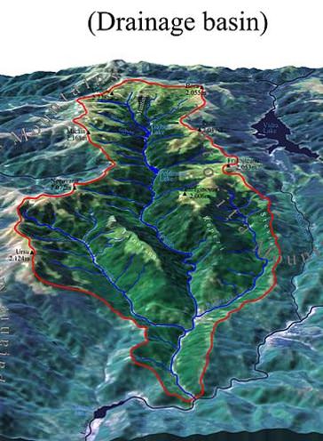
Drainage basin

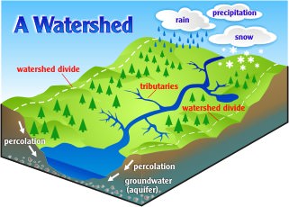
  • Other terms that are used to describe drainage basins are catchment, catchment area, catchment basin, drainage area, river basin, and water basin.
Drainage basin
  • The drainage basin includes both the streams and rivers and the land surface.
  • The drainage basin acts as a funnel by collecting all the water within the area covered by the basin and channeling it to a single point.
  • In closed (“endorheic”) drainage basins the water converges to a single point inside the basin, known as a sink, which may be a permanent lake [Lake Aral], dry lake [some desert lakes], or a point where surface water is lost underground [sink holes in Karst landforms]. Other Examples: Lake Chad [Africa], Dead Sea etc.

Drainage Divide

  • Adjacent drainage basins are separated from one another by a drainage divide. Drainage divide is usually a ridge or a high platform.
  • Drainage divide is conspicuous in case of youthful topography [Himalayas] and it is not well marked in plains [Ganga plains] and senile topography [old featureless landforms – Rolling plateaus of Peninsular region though which South Indian rivers flow].
Drainage Divide

Some important drainage basins across the world

This is Wiki stuff. So can’t guarantee accuracy.

Basin

Type

Continent

Drains to

Basin Area
km2

Amazon RiverPrimary RiverSouth AmericaAtlantic Ocean6,144,727
Hudson BayMediterranean seaNorth AmericaAtlantic Ocean3,861,400
Congo RiverPrimary RiverAfricaAtlantic Ocean3,730,474
Caspian SeaLakeAsia/Europe(endorheic basin == not outlet)3,626,000
Nile RiverPrimary RiverAfricaMediterranean Sea3,254,555
Mississippi-Missouri RiverPrimary RiverNorth AmericaGulf of Mexico3,202,230
Lake ChadLakeAfrican/a (endorheic basin)2,497,918
Black SeaMediterranean seamultipleMediterranean Sea2,400,000
Niger RiverPrimary RiverAfricaAtlantic Ocean2,261,763
Yangtze River (Chang Jiang)Primary RiverAsiaPacific Ocean1,722,155
Baltic SeaMediterranean seaEuropeAtlantic Ocean[4]1,700,000
Ganges–BrahmaputraPrimary RiverAsiaBay of Bengal1,621,000
Indus RiverPrimary RiverAsiaArabian Sea1,081,733

Difference between a River Basin and a Watershed

  • Both river basins and watersheds are areas of land that drain to a particular water body, such as a lake, stream, river or estuary.
  • In a river basin, all the water drains to a large river. The term watershed is used to describe a smaller area of land that drains to a smaller stream, lake or wetland. There are many smaller watersheds within a river basin.
  • Example: watershed of Yamuna + water shed of Chambal + watershed of Gandak + …. = Drainage basin of Ganga.

Drainage patterns

  • Based on the shape and formation of river patters, there are different drainage patterns.

Discordant drainage patterns

  • A drainage pattern is described as discordant if it does not correlate to the topology [surface relief features] and geology [geological features based on both Endogenetic movements and exogenetic movements] of the area.
  • In simple words: In a discordant drainage pattern, the river follows its initial path irrespective of the changes in topography.
  • Discordant drainage patterns are classified into two main types: antecedent and superimposed.

Antecedent Drainage or Inconsequent Drainage

  • A part of a river slope and the surrounding area gets uplifted and the river sticks to its original slope, cutting through the uplifted portion like a saw [Vertical erosion or Vertical down cutting], and forming deep gorges: this type of drainage is called Antecedent drainage.
Example: Indus, Sutlej, Brahmaputra and other Himalayan rivers that are older than the Himalayas themselves. There are usually called as ANTECEDENT RIVERS.

Superimposed or Epigenetic (Discordant) or Superinduced Drainage

  • When a river flowing over a softer rock stratum reaches the harder basal rocks but continues to follow the initial slope, it seems to have no relation with the harder rock bed. This type of drainage is called superimposed drainage.
  • Usually, the drainage patterns (dendritic, trellis, etc.) are strongly influenced by the hardness and softness of the rock and patterns of faults or fractures.
  • Sometimes, however, the land rises rapidly relative to the base level of the stream. This increases the gradient of the stream and therefore, gives the stream more erosive power.
  • The stream has enough erosive power that it cuts its way through any kind of bedrock, maintaining its former drainage pattern.
  • You get a situation, then, where the drainage pattern does not correspond to the hardness or softness of the bedrock or to the locations of faults and fractures.
  • In other words, it is a drainage pattern which exhibits discordance with the underlying rock structure because it originally developed on a cover of rocks that has now disappeared due to denudation.
  • Consequently, river directions relate to the former cover rocks and, as the latter were being eroded, the rivers have been able to retain their courses unaffected by the newly exposed structures.
The stream pattern is thus superposed on, or placed on structural features that were previously buried.
  • The Damodar, the Subarnarekha, the Chambal, the Banas and the rivers flowing at the Rewa Plateau present some good examples of superimposed drainage.
  • Examples: The Damodar, the Subarnarekha, the Chambal, the Banas and the rivers flowing at the Rewa Plateau, rivers of eastern USA and southern France.
  • [In simple words, the river flow becomes independent of present Topography. It flows in its initial paths without being influenced by changing topography].
Antecedent Drainage == Cut through the newly formed landform and maintain the same path == Himalayan Rivers.
Superimposed Drainage == Cut deeper through the existing landform and maintain the same path == Some medium scale rivers of the Northern and Eastern peninsular India.
Antecedent Drainage == The soil formed is weak and it is easily eroded by the rivers.
Superimposed Drainage == The rivers have high erosive power so that they can cut through the underlying strata.
Usually, rivers in both these drainage types flow through a highly sloping surface.

Concordant Drainage Patterns

  • A drainage pattern is described as concordant if it correlates to the topology and geology of the area.
  • In simple words: In a concordant drainage pattern, the path of the river is highly dependent on the slope of the river and topography.
  • Concordant drainage patterns are the most commonly found drainage patterns and are classified into many types.

Consequent Rivers

  • The rivers which follow the general direction of slope are known as the consequent rivers.
  • Most of the rivers of peninsular India are consequent rivers.
  • For example, rivers like Godavari, Krishna and Cauvery, descending from the Western Ghats and flowing into the Bay of Bengal, are some of the consequent rivers of Peninsular India.

Subsequent Rivers

  • A tributary stream that is eroded along an underlying belt of non-resistant rock after the main drainage pattern (Consequent River) has been established is known as a subsequent river.
  • The Chambal, Sind, Ken, Betwa, Tons and Son meet the Yamuna and the Ganga at right angles. They are the subsequent drainage of the Ganga drainage system.
  • These streams have generally developed after the original stream.

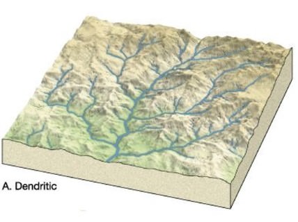
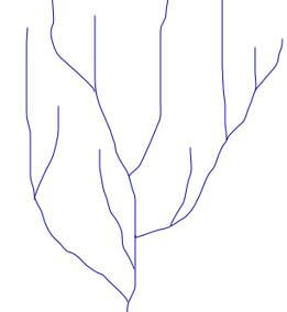
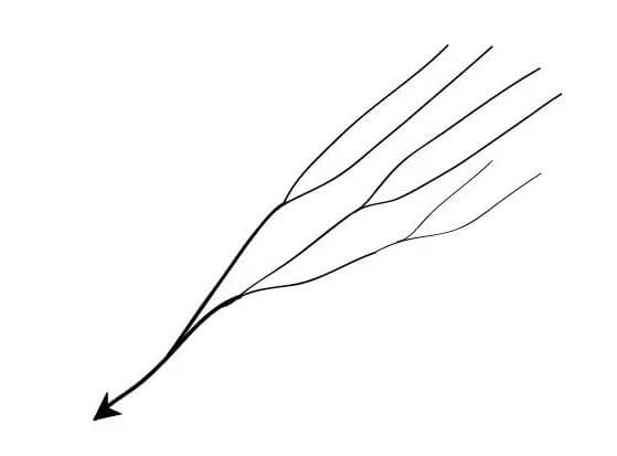
Dendritic or Pinnate Drainage Pattern

Dendric or Pinnate drainage pattern
  • This is an irregular tree branch shaped pattern.
  • Drainage which is branching or ramifying (branch out or cause to branch out) thereby giving the appearance of a tree.
  • A dendritic pattern develops in a terrain which has uniform lithology, and where faulting and jointing are insignificant.
  • Examples: Indus, Godavari, Mahanadi, Cauvery, Krishna.

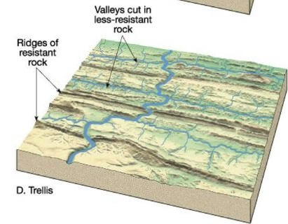
Trellis Drainage Pattern

Trellis
  • In this type of pattern the short subsequent streams meet the main stream at right angles, and differential erosion through soft rocks paves the way for tributaries.
  • Examples: The old folded mountains of the Singhbhum (Chotanagpur Plateau) and Seine and its tributaries in Paris basin (France) have a drainage of trellis pattern.

Angular Drainage Pattern

Angular drainage
  • The tributaries join the main stream at acute angles.
  • This pattern is common in Himalayan foothill regions.

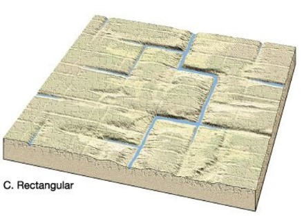
Rectangular Drainage Pattern

Rectangular drainage
  • The main stream bends at right angles and the tributaries join at right angles creating rectangular patterns.
  • This pattern has a subsequent origin.
  • Example: Colorado river (USA), streams found is the Vindhyan Mountains of India.

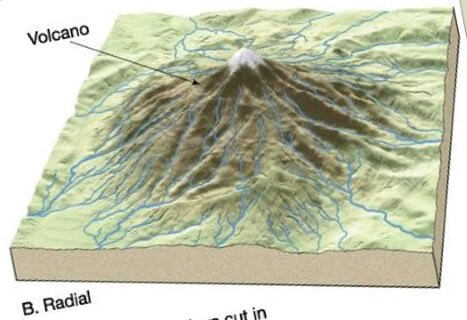
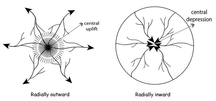
Radial Drainage Pattern

Radial drainage
  • The tributaries from a summit follow the slope downwards and drain down in all directions.
  • Examples: Streams of Saurashtra region, Central French Plateau, Mt. Kilimanjaro.
  • A good example of a radial drainage pattern is provided by the rivers originating from the Amarkantak Mountain.
  • Rivers like Narmada, Son and Mahanadi originating from Amarkantak Hills flow in different directions and are good examples of radial pattern.
  • Radial drainage patterns are also found/in the Girnar Hills (Kathiwar, Gujarat), and Mikir Hills of Assam.

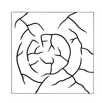
Annular Drainage Pattern

Annular drainage
  • When the upland has an outer soft stratum, the radial streams develop subsequent tributaries which try to follow a circular drainage around the summit.
  • Example: Black Hill streams of South Dakota.
  • This is not a very common drainage pattern in India. Some examples of this are however found in Pithoragarh (Uttarakhand), Nilgiri Hills in Tamil Nadu and Kerala.

Parallel Drainage Pattern

Parallel drainage
  • The tributaries seem to be running parallel to each other in a uniformly sloping region.
  • Example: Rivers of lesser Himalayas and The small and swift rivers originating in the Western Ghats that flow into Arabian Sea.

Centripetal Drainage Pattern

Centripetal drainage
  • In a low lying basin the streams converge from all sides.
  • Examples: streams of Ladakh, Tibet, and the Baghmati and its tributaries in Nepal.

Deranged Drainage Pattern

  • This is an uncoordinated pattern of drainage characteristic of a region recently vacated by an ice-sheet.
  • This type of drainage is found in the glaciated valleys of Karakoram.

Barbed Drainage Pattern

  • A pattern of drainage in which the confluence of a tributary with the main river is characterized by a discordant junction—as if the tributary intends to flow upstream and not downstream.
  • This pattern is the result of capture of the main river which completely reverses its direction of flow, while the tributaries continue to point in the direction of former flow.
  • The Arun River (Nepal), a tributary of the Kosi is an interesting example of barbed drainage pattern
    .