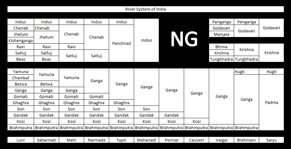
Monday, 16 September 2019


East Flowing Peninsular Rivers: Godavari, Krishna & Mahanadi


East Flowing Peninsular Rivers

  • Mahanadi River
  • Godavari River
  • Krishna River
  • Kaveri (Cauvery) River
  • Pennar River
  • Subarnarekha River
  • Brahamani River
  • Sarada River
  • Ponnaiyar River
  • Vaigai River

Mahanadi River

  • The Mahanadi basin extends over states of Chhattisgarh and Odisha and comparatively smaller portions of Jharkhand, Maharashtra and Madhya Pradesh, draining an area of 1.4 lakh Sq.km.
  • It is bounded by the Central India hills on the north, by the Eastern Ghats on the south and east and by the Maikala range on the west.
  • The Mahanadi (“Great River”) follows a total course of 560 miles (900 km).
  • It has its source in the northern foothills of Dandakaranya in Raipur District of Chhattisgarh at an elevation of 442 m.
  • The Mahanadi is one of the major rivers of the peninsular rivers, in water potential and flood producing capacity, it ranks second to the Godavari.
  • Other small streams between the Mahanadi and the Rushikulya draining directly into the Chilka Lake also forms the part of the basin.
  • The major part of basin is covered with agricultural land accounting to 54.27% of the total area.
  • It is one of the most-active silt-depositing streams in the Indian subcontinent.
  • After receiving the Seonath River, it turns east and enters Odisha state.
  • At Sambalpur the Hirakud Dam (one of the largest dams in India) on the river has formed a man-made lake 35 miles (55 km) long.
  • It enters the Odisha plains near Cuttack and enters the Bay of Bengal at False Point by several channels.
  • Puri, at one of its mouths, is a famous pilgrimage site.
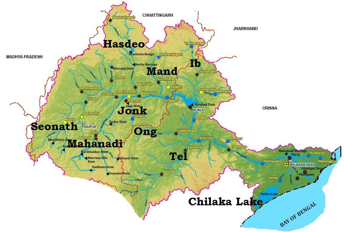
Mahanadi River basin

Tributaries of Mahanadi River

  • Its upper course lies in the saucer-shaped basin called the ‘Chhattisgarh Plain’.
  • This basin is surrounded by hills on the north, west and south as a result of which a large number of tributaries join the main river from these sides.
  • Left bank Tributaries: The Seonath, the Hasdeo, the Mand and the Ib.
  • Right bank Tributaries: The Ong, the Tel and the Jonk.

Projects on Mahanadi River

  • Two important projects completed during pre-plan period in the basin are the Mahanadi main canal and Tandula reservoir in Chhattisgarh.
  • During the plan period, the Hirakud dam, Mahanadi delta project, Hasdeo Bango, Mahanadi Reservoir Project were completed.

Industry in Mahanadi River Basin

  • Three important urban centes in the basin are Raipur, Durg and Cuttack.
  • Mahanadi basin, because of its rich mineral resource and adequate power resource, has a favorable industrial climate.
  • The Important industries presently existing in the basin are the Iron and Steel plant at Bhilaialuminium factories at Hirakud and Korbapaper mill near Cuttack and cement factory at Sundargarh.
  • Other industries based primarily on agricultural produce are sugar and textile mills.
  • Mining of coal, iron and manganese are other industrial activities.

Floods in Mahanadi River Basin

  • The basin is subject to severe flooding occasionally in the delta area due to inadequate carrying capacity of the channels.
  • The multi-purpose Hirakud dam provides some amount of flood relief by storing part of flood water.
  • However, the problem still persists and a lasting solution need to be evolved.

Godavari River

  • The Godavari is the largest river system of the Peninsular India and is revered as Dakshina Ganga.
  • The Godavari basin extends over states of Maharashtra, Andhra Pradesh, Chhattisgarh and Odisha in addition to smaller parts in Madhya Pradesh, Karnataka and Union territory of Puducherry (Yanam) having a total area of ~ 3 lakh Sq.km.
  • The basin is bounded by Satmala hills, the Ajanta range and the Mahadeo hills on the north, by the Eastern Ghats on the south and the east and by the Western Ghats on the west.
  • The Godavari River rises from Trimbakeshwar in the Nashik district of Maharashtra about 80 km from the Arabian Sea at an elevation of 1,067 m.
  • The total length of Godavari from its origin to outfall into the Bay of Bengal is 1,465 km.
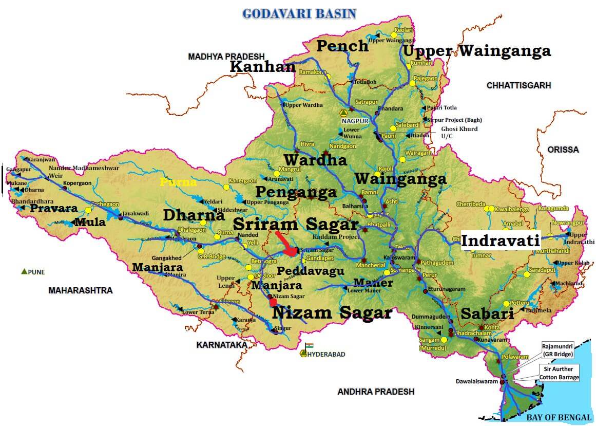
Godavari river Basin

Tributaries of Godavari River

  • The left bank tributaries are more in number and larger in size than the right bank tributaries.
  • The Manjra (724 km) is the only important right bank tributary. It joins the Godavari after passing through the Nizam Sagar.
  • Left Bank Tributaries: Dharna, Penganga, Wainganga, Wardha, Pranahita [conveying the combined waters of Penganga, the Wardha and Wainganga], Pench, Kanhan, Sabari, Indravati etc.
  • Right Bank Tributaries: Pravara, Mula, Manjra, Peddavagu, Maner etc.
  • Below Rajahmundry, the river divides itself into two main streams, the Gautami Godavari on the east and the Vashishta Godavari on the west and forms a large delta before it pours into the Bay of Bengal.
  • The delta of the Godavari is of lobate type with a round bulge and many distributaries.

Mineral Resources in Godavari Basin

  • The upper reaches of the Godavari drainage basin are occupied by the Deccan Traps containing minerals like magnetite, epidote, biotite, zircon, chlorite etc (metallic minerals)..
  • The middle part of the basin is principally composed of phyllites, quartzites, amphiboles and granites (rocks).
  • The downstream part of the middle basin is occupied mainly by sediments and rocks of the Gondwana group.
  • The Gondwanas are principally detritals (waste or debris, in particular organic matter produced by decomposition or loose matter produced by erosion) with some thick coal seams. [Singareni Coal Seam]
  • The Eastern Ghats dominate the lower part of the drainage basin and are formed mainly from the Khondalites.

Projects on Godavari River

  • Important projects completed duing the plan period are Srirama Sagar, Godavari barrage, Upper Penganga, Jaikwadi, Upper Wainganga, Upper Indravati, Upper Wardha.
  • Among the on-going projects, the prominent ones are Prnahita-Chevala and Polavaram.

Industry in Godavari Basin

  • The major urban Centers in the basin are Nagpur, Aurangabad, Nashik, Rajhmundry.
  • Nashik and Aurangabad have large number of industries especially automobile.
  • Other than this, the industries in the basin are mostly based on agricultural produce such as rice milling, cotton spinning and weaving, sugar and oil extraction.
  • Cement and some small engineering industries also exist in the basin.

Floods and Droughts in Godavari Basin

  • Godavari basin faces flooding problem in its lower reaches.
  • The coastal areas are cyclone-prone.
  • The delta areas face drainage congestion due to flat topography.
  • A large portion of Maharashtra falling (Marathwada) in the basin is drought prone.

Krishna River

  • The Krishna is the second largest east flowing river of the Peninsula.
  • The Krishna Basin extends over Andhra Pradesh, Maharashtra and Karnataka having a total area of ~2.6 lakh Sq.km.
  • It is bounded by Balaghat range on the north, by the Eastern Ghats on the south and the east and by the Western Ghats on the west.
  • The Krishna River rises from the Western Ghats near Jor village of Satara district of Maharashtra at an altitude of 1,337 m just north of Mahabaleshwar.
  • The total length of river from origin to its outfall into the Bay of Bengal is 1,400 km.
  • The major part of basin is covered with agricultural land accounting to 75.86% of the total area.
  • The Krishna forms a large delta with a shoreline of about 120 km. The Krishna delta appears to merge with that formed by the Godavari and extends about 35 km into the sea.
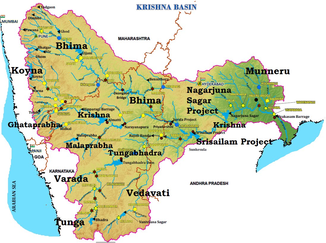
Krishna river Basin

Tributaries of Krishna River

  • Right bank: the Ghatprabha, the Malprabha and the Tungabhadra.
  • Left Bank: the Bhima, the Musi and the Munneru.
  • The Koyna is a small tributary but is known for Koyna Dam. This dam was perhaps the main cause of the devastating earthquake (6.4 on richter scale) in 1967 that killed 150 people.
  • The Bhima originates from the Matheron Hills and joins the Krishna near Raichur after for a distance of 861 km.
  • The Tungabhadra is formed by the unification of the Tunga and the Bhadra originating from Gangamula in the Central Sahyadri. Its total length is 531 km.
  • At Wazirabad, it receives its last important tributary, the Musi, on whose banks the city of Hyderabad is located.

Projects on Krishna River

  • Important ones are the Tungabhadra, Ghataprabha, Nagarjunasagar, Malaprabha, Bhima, Bhadra and Telugu Ganga.
  • The major Hydro Power stations in the basin are Koyna, Tungabhadara, Sri Sailam, Nagarjuna Sagar, Almatti, Naryanpur, Bhadra.
  • Tunagabhadra is a major inter-States project in the basin. In order to operate the project and to regulate the flows among the beneficiary States of Karnataka and Andhara Pradesh.

Resources in Krishna Basin

  • The basin has rich mineral deposits and there is good potential for industrial development.
  • Iron and steel, cement, sugar cane vegetable oil extraction and rice milling are important industrial activities at present in the basin.
  • Recently oil has been struck in this basin which is bound to have an effect on the future industrial scenario of this basin.

Industry in Krishna Basin

  • The major Urban Centers in the Basin are Pune, Hyderabad.
  • Hyderabad is the state capital of Telangana and is now a major IT hub.
  • Pune in Maharashtra has number of automobile and IT industry and is major education centre.

Drought and Floods in Krishna Basin

  • Some parts of the basin, especially the Rayalaseema area of Andhra Pradesh, Bellary, Raichur, Dharwar, Chitradurga, Belgaum and Bijapur districts of Karnataka and Pune, Sholapur, Osmanabad and Ahmedanagar districts of Maharashtra are drought-prone.
  • The delta area of the basin is subject to flooding. It has been observed that the river bed in delta area is continuously raised due to silt deposition resulting in reduction in carrying capacity of the channel.
  • The coastal cyclonic rainfall of high intensity and short duration makes the flood problem worse
    .
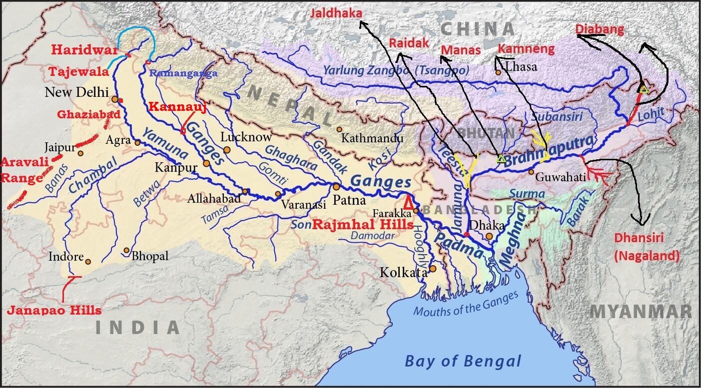
Ganga-Brahmaputra River System: Major Tributaries of The Ganga & Brahmaputra


Ganga River System

ganaga river system - tributaries ganga yamunariver systems of India-indus-ganga-godavari-cauvery
  • All Pics from Wikipedia

River

Source

Bhagirathi (Ganga)Gangotri glacier
YamunaYamnotri glacier on the Bandarpunch Peak
ChambalJanapao Hills in the Vindhya Range
BanasAravali Range
BetwaBhopal district
KenBarner Range
SonAmarkantak Plateau
Damodar (‘Sorrow of Bengal’)Chotanagpur plateau
Ramganga RiverGarhwal district of Uttarakhand
Ghaghra River

Gurla Mandhata peak, south of Manasarovar in Tibet (river of the trans-Himalayan origin)
The Kali River (border between Nepal and Uttarakhand)Glaciers of trans-Himalayas
Gandak RiverTibet-Nepal border
Burhi GandakSumesar hills near the India-Nepal border
Kosi (‘Sorrow of Bihar’)Tumar, Arun and Sun Kosi unite at Triveni north of the Mahabharata Range to form the Kosi.

Ganga River

  • The Ganga originates as Bhagirathi from the Gangotri glacier in Uttar Kashi District of Uttarakhand at an elevation of 7,010 m.
  • Alaknanda River joins Bhagirathi at Devaprayag.
  • From Devapryag the river is called as Ganga.
  • The Ganges was ranked as the fifth most polluted river of the world in 2007.
  • Pollution threatens many fish species and amphibian species and the endangered Ganges river dolphin (Blind Dolphin).
  •  The Ganga Action Plan, an environmental initiative to clean up the river, has been a major failure thus far, due to corruption, lack of technical expertise, poor environmental planning, and lack of support from religious authorities.

Major tributaries of Alaknanda

  • East Trisul (joins Alaknanda at Karan Prayag)
  • Pindar (rises from Nanda Devi)
  • Mandakini or Kali Ganga (joins Alaknanda at Rudra Prayag)
  • Dhauliganga
  • Bishenganga.
[Kishenganga is the tributary of Jhelum]

Major tributaries of Bhagirathi

  • Bheling
  • Ganga debouches [emerge from a confined space into a wide, open area] from the hills into plain area at
  • It is joined by the Yamuna at Allahabad.
  • Near Rajmahal Hills it turns to the south-east.
  • At Farraka, it bifurcates into Bhagirathi-Hugli in West Bengal and Padma-Meghna in Bangladesh (it ceases to be known as the Ganga after Farraka).
  • Brahmaputra (or the Jamuna as it is known here) joins Padma-Meghna at
  • The total length of the Ganga river from its source to its mouth (measured along the Hugli) is 2,525 km.

Ganga – Brahmaputra Delta

  • Before entering the Bay of Bengal, the Ganga, along with the Brahmaputra, forms the largest delta of the world between the Bhagirathi/Hugli and the Padma/Meghna covering an area of 58,752 sq km.
  • The coastline of delta is a highly indented area.
  • The delta is made of a web of distributaries and islands and is covered by dense forests called the
  • A major part of the delta is a low-lying swamp which is flooded by marine water during high tide.

Right Bank Tributaries of The Ganga

  • Most of them except Yamuna originate in the peninsular region.

Yamuna River

  • Largest and the most important tributary.
  • It originates from the Yamnotri glacier on the Bandarpunch Peak in the Garhwal region in Uttarakhand at an elevation of about 6,000 meters.
  • It cuts across the Nag Tibba, the Mussoorie and the Shiwalik ranges.
  • It emerges out of the hilly area and enters plains near
  • Its main affluent in the upper reaches is the Tons which also rises from the Bandarpunch glacier.
  • It joins Yamuna below Kalsi before the latter leaves the hills.
  • At this site, the water carried by the Tons is twice the water carried by the Yamuna.
yamuna river tributaries-son-ken-betwa-banas

Non – Peninsular Tributaries

1.   Rishiganga
2.   Uma
3.   Hanuman Ganga and
4.   Tons join it in the mountains.
5.   Hindon joins at Ghaziabad in the plain area

Peninsular Tributaries

Most of the Peninsular rivers flow into the Yamuna between Agra and Allahabad.
1.   Chambal
2.   Sind
3.   Betwa
4.   Ken.
  • It unites with the Ganga near Triveni Sangam, Allahabad.
  • The total length of the Yamuna from its origin till Allahabad is 1,376 km.
  • It creates the highly fertile alluvial, Yamuna-Ganges Doab region between itself and the Ganges in the Indo-Gangetic plain.

Chambal River

  • The Chambal rises in the highlands of Janapao Hills (700 m) in the Vindhyan Range.
  • It flows through the Malwa Plateau.
  • It joins the Yamuna in Etawah district of Uttar Pradesh.
  • The river flows much below its banks due to severe erosion because of poor rainfall and numerous deep ravines have been formed in the Chambal Valley, giving rise to badland topography. {Arid Landforms}
  • The total length of the river is 1,050 km.

Dams on the Chambal

  • The Gandhi Sagar dam is the first of the four dams built on the Chambal River, located on the Rajasthan-Madhya Pradesh border.
  • The Rana Pratap Sagar dam is a dam located 52 km downstream of Gandhi Sagar dam on across the Chambal River in Chittorgarh district in Rajasthan.
  • The Jawahar Sagar Dam is the third dam in the series of Chambal Valley Projects, located 29 km upstream of Kota city and 26 km downstream of Rana Pratap Sagar dam.
  • The Kota Barrage is the fourth in the series of Chambal Valley Projects, located about 0.8 km upstream of Kota City in Rajasthan.
  • Water released after power generation at Gandhi Sagar dam, Rana Pratap Sagar dam and Jawahar Sagar Dams, is diverted by Kota Barrage for irrigation in Rajasthan and in Madhya Pradesh through canals.
Keoladeo National Park is supplied with water from Chambal river irrigation project.

Banas River

  • The Banas is a tributary of the Chambal.
  • It originates in the southern part of the Aravali Range.
  • It join the Chambal on Rajasthan – Madhya Pradesh border near Sawai Madhopur.

Sind River

  • The Sind originates in Vidisha Plateau of Madhya Pradesh.
  • It flows for a distance of 415 km before it joins the Yamuna.

Betwa River

  • The Betwa rises in Bhopal district (Vindhyan Range) and joins the Yamuna near
  • It has a total length of 590 km.
  • The Dhasan is its important tributary.

Ken River

  • The Ken river rising from the Barner Range of Madhya Pradesh joins the Yamuna near Chila.

Son River

  • The Son River rises in the Amarkantak Plateau.
  • Its source is close to the origin of the Narmada.
  • It passes along the Kaimur Range.
  • It joins the Ganga near Danapur in Patna district of Bihar.
  • It flows for a distance of 784 km from its source.
  • The important tributaries of the Son are the Johilla, the Gopat, the Rihand, the Kanhar and the North Koel. Almost all the tributaries join it on its right bank.

Damodar river

  • The Damodar river rises in the hills of the Chotanagpur plateau and flows through a rift valley.
  • Rich in mineral resources, the valley is home to large-scale mining and industrial activity.
  • It has a number of tributaries and subtributaries, such as Barakar, Konar, Bokaro, Haharo, etc.
  • The Barakar is the most important tributary of the Damodar.
  • Several dams have been constructed in the valley, for the generation of hydroelectric power. The valley is called “the Ruhr of India”.
  • The first dam was built across the Barakar River, a tributary of the Damodar river.
  • It used to cause devastating floods as a result of which it earned the name ‘Sorrow of Bengal’. Now the river is tamed by constructing numerous dams.
  • It joins the Hugli River 48 km below Kolkata.
  • The total length of the river is 541 km.

Left Bank Tributaries of The Ganga River

  • These rivers originate in the Himalayas.
  • The major tributaries apart from the Yamuna, are the Ramganga, the Gomati, the Ghaghra, the Gandak, the Burhi Gandak, the Bagmati, and the Kosi.

Ramganga River

  • The Ramganga river rises in the Garhwal district of Uttarakhand.
  • It enters the Ganga Plain near Kalagarh.
  • It joins the Ganga at
  • The Khoh, the Gangan, the Aril, the Kosi, and the Deoha (Gorra) are important tributaries of Ramganga.

Ghaghra River

  • Its source is near Gurla Mandhata peak, south of Manasarovar in Tibet (river of the trans-Himalayan origin).
  • It is known as the Karnaili in Western Nepal.
  • Its important tributaries are the Sarda, the Sarju (Ayodhya is located on its bank) and the Rapti.
  • The Ghaghara joins the Ganga a few kilometres downstream of Chhapra in Bihar.
  • After reaching the plain area, its stream gets divided into many branches of which, Koriyab and Garwa are important.
  • The river bed is sandy and sudden bends start occurring in the stream.
  • The river has a high flood frequency and has shifted its course several times.

Kali River

  • Rises in the high glaciers of trans-Himalaya.
  • It forms the boundary between Nepal and Kumaon.
  • It is known as the Sarda after it reaches the plains near Tanakpur.
  • It joins the

Gandak River

  • Originates near the Tibet-Nepal border at a height of 7,620 m
  • It receives a large number of tributaries in Nepal Himalaya.
  • Its important tributaries are the Kali Gandak, the Mayangadi, the Bari and the Trishuli.
  • It debouches into the plains at
  • It flows into Ganga at Hajipur in Bihar.

Burhi Gandak

  • Originates from the western slopes of Sumesar hills near the India-Nepal border.
  • It joins the Ganga near Monghyr town.

Kosi River

  • The Kosi river consists of seven streams namely Sut Kosi, Tamba Kosi, Talkha, Doodh Kosi, Botia Kosi, Arun and Tamber and is popularly known as
  • These streams flow through eastern Nepal which is known as the Sapt Kaushik region.
  • The sources of seven streams of the Kosi are located in snow covered areas which also receive heavy rainfall.
  • Consequently, huge volume of water flows with tremendous speed.
  • Seven streams mingle with each other to form three streams named the Tumar, Arun and Sun Kosi.
  • They unite at Triveni north of the Mahabharata Range to form the Kosi.
  • The river enters the Tarai of Nepal after cutting a narrow gorge in the Mahabharata Range.
  • The joins the Ganga near
  • Soon after debouching onto the plain the river becomes sluggish.
  • Large scale deposition of eroded material takes place in the plain region.
  • The river channel is braided and it shifts its course frequently. This has resulted in frequent devastating floods and has converted large tracts of cultivable land into waste land in Bihar. Thus the river is often termed as the ‘Sorrow of Bihar’.
  • In order to tame this river, a barrage was constructed in 1965 near Hanuman Nagar in Nepal.
  • Embankments for flood control have been constructed as a joint venture of India and Nepal.

Brahmaputra River System

Region

Name

TibetTsangpo (meaning ‘The Purifier’)
ChinaYarlung Zangbo Jiangin
Assam ValleyDihang or Siong, South of Sadiya: Brahmaputra
BangladeshJamuna River
Padma River: Combined Waters of Ganga and Brahmaputra
Meghana: From the confluence of Padma and Meghna [View image above]
  • The Brahmaputra (meaning the son of Brahma).
  • It is 2,900 km in length.
  • Source: Chemayungdung glacier (Kailas Range) at an elevation of about 5,150 m. It’s source is very close to the sources of Indus and Satluj.
  • Mariam La separates the source of the Brahmaputra from the Manasarovar Lake.
  • Brahmaputra flows eastwards in Southern Tibet for about 1,800 km.
  • In Tibet it passes through the depression formed by the Indus-Tsangpo Structure Zone between the Great Himalayas in the south and the Kailas Range in the north.
  • Inspite of the exceptionally high altitude, the Tsangpo has a gentle slope. The river is sluggish and has a wide navigable channel for about 640 km.
  • It receives a large number of tributaries in Tibet. The first major tributary is the Raga Tsangpo meeting the Tsangpo near Lhatse Dzong.
  • The river Ngangchu flows through the trade centre of Gyantse in the south and joins the main river.
  • Towards the end of its journey in Tibet, its course abruptly takes a south ward turn around Namcha Barwa (7,756 m)(Syntaxial Bend).
  • Here it cuts across the eastern Himalaya through the Dihang or Siang Gorge and emerges from the mountains near Sadiya in the Assam Valley.
  • Here it first flows under the name of Siong and then as the Dihang.
  • In the north-eastern parts of Assam Valley, it is joined by two important tributaries viz, the Dibang (or Sikang) from the north and Lohit from the south.
  • From Sadiya (Assam Valley) onwards, this mighty river is known as the
  • The main streams merging with the Brahmaputra from the north are, Subansiri, Kameng, Dhansiri (north), Raidak, Tista etc..
  • The Tista was a tributary of the Ganga prior to the floods of 1787 after which it diverted its course eastwards to join the Brahmaputra.
  • The Brahmaputra has a braided channel (flow into shallow interconnected channels divided by deposited earth) for most of its passage through Assam where channels keep shifting. It carries a lot of silt and there is excessive meandering.
  • The river is nearly 16 km wide at Dibrugarh and forms many islands, the most important of which is MAJULI. It is 90 km long and measures 20 km at its widest.
  • With rainfall concentrated during the monsoon months only the river has to carry enormous quantities of water and silt which results in disastrous floods. The Brahmaputra is thus truly a River of Sorrow.
  • The river is navigable for a distance of 1,384 km upto Dibrugarh from its mouth and serves as an excellent inland water transport route.
  • Brahmaputra bends southwards and enters Bangladesh near Dhubri.
  • It flows for a distance of 270 km in the name of Jamuna river and joins the Ganga at
  • The united stream of the Jamuna and the Ganga flows further in the name of
  • About 105 km further downstream, the Padma is joined on the left bank by the Meghna, originating in the mountainous region of Assam.
  • From the confluence of Padma and Meghna, the combined river is known as the Meghna which makes a very broad estuary before pouring into the Bay of Bengal
    .