Natural Vegetation of India: Moist Tropical, Dry Tropical, Montane Sub-tropical, Montane Temperate & Alpine Forests
Table of Contents
Forests – Natural Vegetation of India – Classification of Natural Vegetation of India: Moist Tropical, Dry Tropical, Montane Sub-tropical, Montane Temperate, Alpine Forests.
Forests – Natural Vegetation of India
- Climate, soil and topography are the major factors that influence Natural Vegetation of a place.
- The main climatic factors are rainfall and temperature. The amount of annual rainfall has a great bearing on the type of vegetation.
Annual Rainfall | Type of Vegetation |
200 cm or more | Evergreen Rain Forests |
100 to 200 cm | Monsoon Deciduous Forests |
50 to 100 cm | Drier Deciduous or Tropical Savanna |
25 to 50 cm | Dry Thorny Scrub (Semi-arid) |
Below 25 cm | Desert (Arid) |
- Temperature is the major factor in Himalayas and other hilly regions with an elevation of more than 900 metres.
- As the temperature falls with altitude in the Himalayan region the vegetal cover changes with altitude from tropical to sub-tropical, temperate and finally alpine.
- Soil is an equally determining factor in few regions. Mangrove forests, swamp forests are some of the examples where soil is the major factor.
- Topography is responsible for certain minor types e.g. alpine flora, tidal forests, etc..
Classification of Natural Vegetation of India
- Classification of Natural Vegetation of India is primarily based on spatial and annual variations in rainfall. Temperature, soil and topography are also considered.
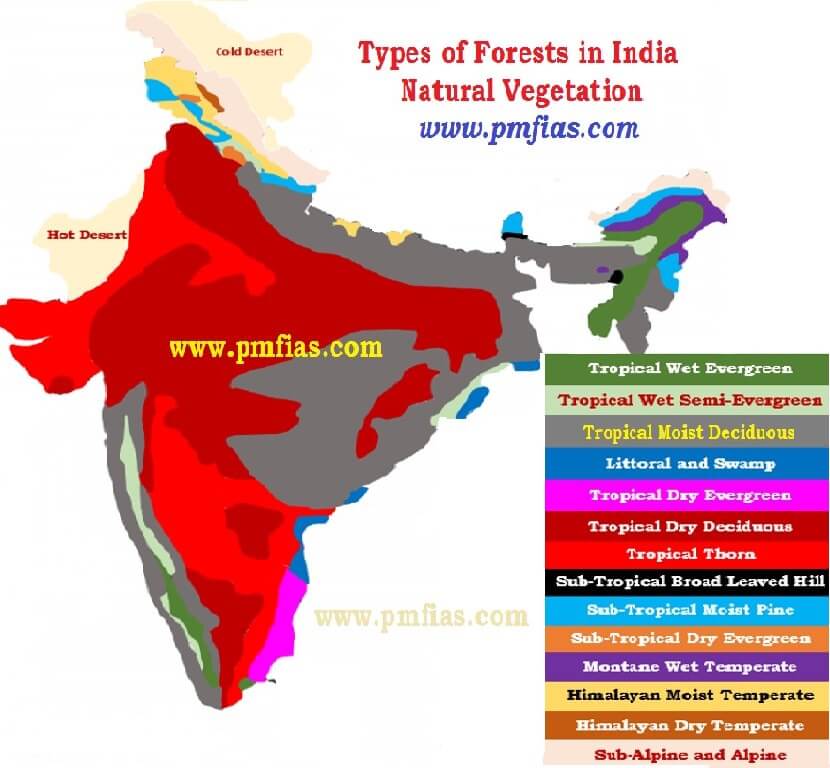
- India’s vegetation can be divided into 5 main types and 16 sub-types as given below.
A. Moist Tropical Forests
- Tropical Wet Evergreen
- Tropical Semi-Evergreen
- Tropical Moist Deciduous
- Littoral and Swamp
B. Dry Tropical Forests
- Tropical Dry Evergreen
- Tropical Dry Deciduous
- Tropical Thorn
C. Montane Sub-tropical Forests
- Sub-tropical broad leaved hill
- Sub-tropical moist hill (pine)
- Sub-tropical dry evergreen
D. Montane Temperate Forests
- Montane Wet Temperate
- Himalayan Moist Temperate
- Himalayan Dry Temperate
E. Alpine Forests
- Sub-Alpine
- Moist Alpine scrub
- Dry Alpine scrub
Forest Type in India | % of Total Area |
| Tropical Moist Deciduous | 37 |
| Tropical Dry Deciduous | 28 |
| Tropical Wet Evergreen | 8 |
| Sub-Tropical Moist Hill | 6 |
| Tropical Semi-Evergreen | 4 |
| Rest below 4 % | |
Moist Tropical Forests
Tropical Wet Evergreen Forests or Rain Forests
Climatic Conditions
- Annual rainfall exceeds 250 cm
- The annual temperature is about 25°-27°C
- The average annual humidity exceeds 77 per cent and
- The dry season is distinctly short.
Characteristics
- Evergreen: Due to high heat and high humidity, the trees of these forests do not shed their leaves together.
- Mesosphytic: Plants adopted to neither too dry nor too wet type climate.
What are mesophytes?
|
- Lofty: The trees often reach 45 – 60 metres in height.
- Thick Canopy: From the air, the tropical rain forest appears like a thick canopy of foliage, broken only where it is crossed by large rivers or cleared for cultivation.
- All plants struggle upwards (most ephiphytes) for sunlight resulting in a peculiar layer arrangement. The entire morphology looks like a green carpet when viewed from above.

- Less undergrowth: The sun light cannot reach the ground due to thick canopy. The undergrowth is formed mainly of bamboos, ferns, climbers, orchids, etc.
Distribution
- Western side of the Western Ghats (500 to 1370 metres above sea level).
- Some regions in the Purvanchal hills.
- In the Andaman and Nicobar Islands.
Timber
- Hardwood: The timber of these forests is fine-grained, hard and durable.
- It has high commercial value but it is highly challenging to exploit due to dense undergrowth, absence of pure stands and lack of transport facilities [Read previous posts on Climatic regions to understand how lumbering industry works in Equatorial Rainforests (hardwood) and Taiga Climatic (softwood) conditions].
- The important species of these forests are mahogany, mesua, white cedar, jamun, canes, bamboo etc.
Tropical Semi-Evergreen Forests
- They are transitional forests between tropical wet evergreen forests and tropical deciduous forests.
- They are comparatively drier areas compared to tropical wet evergreen forests.
Climatic Conditions
- Annual rainfall is 200-250 cm
- Mean annual temperature varies from 24°C to 27°C
- The relative humidity is about 75 per cent
- The dry season is not short like in tropical evergreen forests.
Distribution
- Western coast
- Assam
- Lower slopes of the Eastern Himalayas
- Odisha and
- Andamans.
Characteristics
- The semi-evergreen forests are less dense.
- They are more gregarious [living in flocks or colonies – more pure stands] than the wet evergreen forests.
- These forests are characterized by many species.
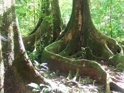
- Trees usually have buttressed trunks with abundant epiphytes.
- The important species are laurel, rosewood, mesua, thorny bamboo – Western Ghats, white cedar, Indian chestnut, champa, mango, etc. – Himalayan region.
Timber
- Hardwood: Similar to that in tropical evergreen forests except that these forests are less dense with more pure stands (timber industry here is better than in evergreen forests).
Tropical Moist Deciduous Forests
Climatic Conditions
- Annual rainfall 100 to 200 cm.
- Mean annual temperature of about 27°C
- The average annual relative humidity of 60 to 75 per cent.
- Spring (between winter and summer) and summer are dry.
Characteristics
- The trees drop their leaves during the spring and early summer when sufficient moisture is not available.
- The general appearance is bare in extreme summers (April-May).
- Tropical moist deciduous forests present irregular top storey [25 to 60 m].
- Heavily buttressed trees and fairly complete undergrowth.
- These forests occupy a much larger area than the evergreen forests but large tracts under these forests have been cleared for cultivation.
Distribution
- Belt running along the Western Ghats surrounding the belt of evergreen forests.
- A strip along the Shiwalik range including terai and bhabar from 77° E to 88° E.
- Manipur and Mizoram.
- Hills of eastern Madhya Pradesh and Chhattisgarh.
- Chota Nagpur Plateau.
- Most of Odisha.
- Parts of West Bengal and
- Andaman and Nicobar islands.
Timber
- These provide valuable timer like Teak.
- The main species found in these forests are teak, sal, laurel, rosewood, amla, jamun, bamboo, etc.
- It is comparatively easy to exploit these forests due to their high degree of gregariousness (more pure stands).
Littoral and Swamp Forests
- They can survive and grow both in fresh as well as brackish water (The mixture of seawater and fresh water in estuaries is called brackish water and its salinity can range from 0.5 to 35 ppt).
- Occur in and around the deltas, estuaries and creeks prone to tidal influences (delta or tidal forests).
- Littoral (relating to or on the shore of the sea or a lake) forests occur at several places along the coast.
- Swamp forests are confined to the deltas of the Ganga, the Mahanadi, the Godavari, the Krishna and the Cauvery.
- Dense mangroves occur all along the coastline in sheltered estuaries, tidal creeks, backwaters, salt marshes and mudflats. It provides useful fuel wood.
- The most pronounced and the densest is the Sunderban in the Ganga delta where the predominant species is Sundri (Heriteera).
Timber
- It provides hard and durable timber which is used for construction, building purposes and making boats.
- The important species found in these forests are Sundri, agar, rhizophora, screw pines, canes and palms, etc.
Dry Tropical Forests
Tropical Dry Evergreen Forests
Distribution
- Along the coasts of Tamil Nadu.
Climatic Conditions
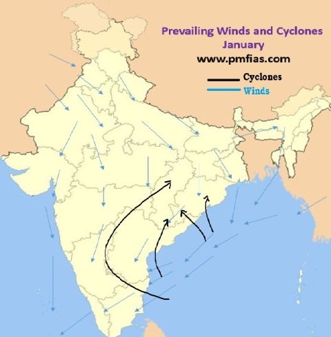
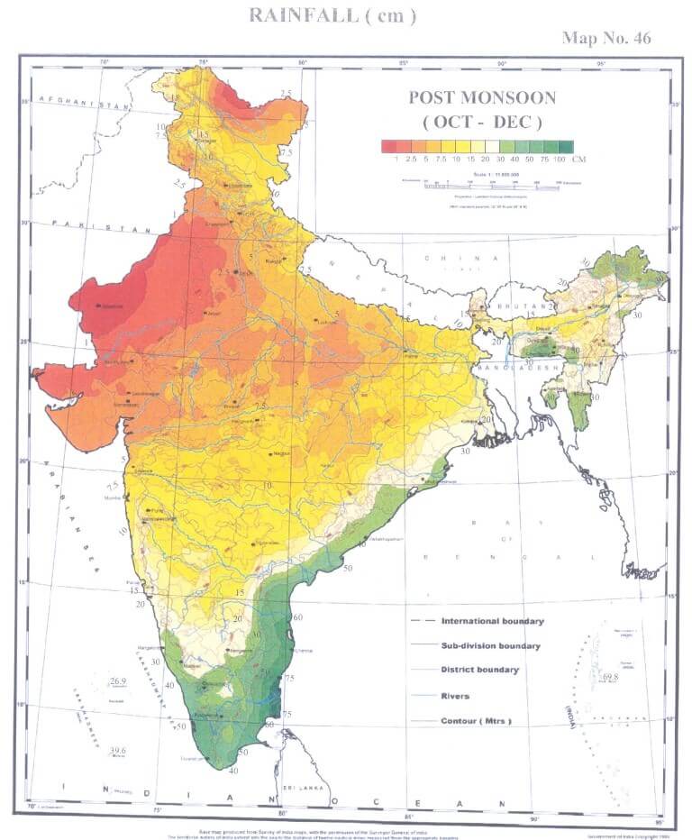
- Annual rainfall of 100 cm [mostly from the north-east monsoon winds in October – December].
- Mean annual temperature is about 28°C.
- The mean humidity is about 75 per cent.
- The growth of evergreen forests in areas of such low rainfall is a bit strange.
Characteristics
- Short statured trees, up to 12 m high, with complete canopy.
- Bamboos and grasses not conspicuous.
- The important species are jamun, tamarind, neem, etc.
- Most of the land under these forests has been cleared for agriculture or casuarina plantations.
Casuarina plantation
 Distribution
Benefits
Wasteland development
|
Tropical Dry Deciduous Forests
Climatic Conditions
- Annual rainfall is 100-150 cm.
Characteristics
- These are similar to moist deciduous forests and shed their leaves in dry season.
- The major difference is that they can grow in areas of comparatively less rainfall.
- They represent a transitional type – moist deciduous on the wetter side and thorn forests on the drier side.
- They have closed but uneven canopy.
- The forests are composed of a mixture of a few species of deciduous trees rising up to a height of 20 metres.
- Undergrowth: Enough light reaches the ground to permit the growth of grass and climbers.
Distribution
- They occur in an irregular wide strip running from the foot of the Himalayas to Kanniyakumari except in Rajasthan, Western Ghats and West Bengal.
- The important species are teak, axlewood, rosewood, common bamboo, red sanders, laurel, satinwood, etc.
- Large tracts of this forest have been cleared for agricultural purposes.
- These forests have suffer from over grazing, fire, etc.
Tropical Thorn Forests
Climatic Conditions
- Annual rainfall less than 75 cm.
- Humidity is less than 50 per cent.
- Mean temperature is 25°-30°C.
Characteristics
- The trees are low (6 to 10 metres maximum) and widely scattered.
- Acacias and Euphorbias are very prominent.
- The Indian wild date is common. Some grasses also grow in the rainy season.
Distribution
- Rajasthan, south-western Punjab, western Haryana, Kachchh and neighbouring parts of Saurashtra.
- Here they degenerate into desert type in the Thar desert.
- Such forests also grow on the leeside of the Western Ghats covering large areas of Maharashtra, Karnataka, Telangana, Andhra Pradesh and Tamil Nadu.
- The important species are neem, babul, cactii, etc.
Montane Sub-Tropical Forests
Sub-tropical Broad-leaved Hill Forests
Climatic conditions
- Mean annual rainfall is 75 cm to 125 cm.
- Average annual temperature is 18°-21°C.
- Humidity is 80 per cent.
Distribution
- Eastern Himalayas to the east of 88°E longitude at altitudes varying from 1000 to 2000 m.
Characteristics
- Forests of evergreen species.
- Commonly found species are evergreen oaks, chestnuts, ash, beech, sals and pines.
- Climbers and epiphytes [a plant that grows non-parasitically on a tree or other plant] are common.
- These forests are not so distinct in the southern parts of the country. They occur only in the Nilgiri and Palni hills at 1070-1525 metres above sea level.
- It is a “stunted rain-forest” and is not so luxuriant as the true tropical evergreen.
- The higher parts of the Western Ghats such as Mahabaleshwar, the summits of the Satpura and the Maikal Range, highlands of Bastar and Mt. Abu in the Aravali Range carry sub-types of these forests.
Sub-tropical Moist Pine Forests
Distribution
- Western Himalayas between 73°E and 88°E longitudes at elevations between 1000 to 2000 metres above sea level.
- Some hilly regions of Arunachal Pradesh, Manipur, Naga Hills and Khasi Hills.
Timber
- Chir or Chil is the most dominant tree which forms pure stands.
- It provides valuable timber for furniture, boxes and buildings.
- It is also used for producing resin and turpentine.
Sub-tropical Dry Evergreen Forests
Distribution
- Found in the Bhabar, the Shiwaliks and the western Himalayas up to about 1000 metres above sea level.
Climatic Conditions
- Annual rainfall is 50-100 cm (15 to 25 cm in December-March).
- The summers are sufficiently hot and winters are very cold.
Characteristics
- Low scrub forest with small evergreen stunted trees and shrubs.
- Olive, acacia modesta and pistacia are the most predominant species.
Montane Temperate Forests
Montane Wet Temperate Forests
Climatic Conditions
- Grows at a height of 1800 to 3000 m above sea level
- Mean annual rainfall is 150 cm to 300 cm
- Mean annual temperature is about 11°C to 14°C and the
- Average relative humidity is over 80 per cent.
Distribution
- Higher hills of Tamil Nadu and Kerala, in the Eastern Himalayan region.
Characteristics
- These are closed evergreen forests. Trunks have large girth.
- Branches are clothed with mosses, ferns and other epiphytes.
- The trees rarely achieve a height of more than 6 metres.
- Deodar, Chilauni, Indian chestnut, birch, plum, machilus, cinnamomum, litsea, magnolia, blue pine, oak, hemlock, etc. are important species.
Himalayan Moist Temperate Forests
Climatic Conditions
- Annual rainfall varies from 150 cm to 250 cm
Distribution
- Occurs in the temperate zone of the Himalayas between 1500 and 3300 metres.
- Cover the entire length of this mountain range in Kashmir, Himachal Pradesh, Uttarakhand, Darjeeling and Sikkim.
Characteristics
- Mainly composed of coniferous species.
- Species occur in mostly pure strands.
- Trees are 30 to 50 m high.
- Pines, cedars, silver firs, spruce, etc. are most important trees.
- They form high but fairly open forest with shrubby undergrowth including oaks, rhododendrons and some bamboos.
Timber
- It provides fine wood which is of much use for construction, timber and railway sleepers.
Himalayan Dry Temperate Forests
Climatic Conditions
- Precipitation is below 100 cm and is mostly in the form of snow.
Characteristics
- Coniferous forests with xerophytic shrubs in which deodar, oak, ash, olive, etc are the main trees.
Distribution
- Such forests are found in the inner dry ranges of the Himalayas where south-west monsoon is very feeble.
- Such areas are in Ladakh, Lahul, Chamba, Kinnaur, Garhwal and Sikkim.
Alpine Forests
- Altitudes ranging between 2,900 to 3,500.
- These forests can be divided into: (1) sub-alpine; (2) moist alpine scrub and (3) dry alpine scrub.
- The sub-alpine forests occur lower alpine scrub and grasslands.
- It is a mixture of coniferous and broad-leaved trees in which the coniferous trees attain a height of about 30 m while the broad leaved trees reach only 10 m.
- Fir, spruce, rhododendron, etc. are important species.
- The moist alpine scrub is a low evergreen dense growth of rhododendron, birch etc. which occurs from 3,000 metres and extends upto snowline.
- The dry alpine scrub is the uppermost limit of scrub xerophytic, dwarf shrubs, over 3,500 metres above sea level and found in dry zone. Juniper, honeysuckle, artemesia etc. are important species
.
