Monday, 16 September 2019


Indian Islands: Andaman & Nicobar Islands, Lakshadweep Islands & New Moore Island


Indian Islands

  • The major islands groups of India are Andaman and Nicobar Archipelago (A chain of islands similar in origin) in Bay of Bengal and Lakshadweep islands in Arabian Sea.
Reunion Hotspot Volcanism
  • Andaman and Nicobar Islands were formed due to collision between Indian Plate and Burma Minor Plate [part of Eurasian Plate][Similar to formation of Himalayas].
  • Andaman and Nicobar Islands are southward extension of Arakan Yoma range [Myanmar][Arakan Yoma in itself is an extension of Purvanchal Hills].
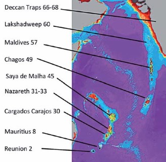
  • Lakshadweep Islands are coral islands. These islands are a part Reunion Hotspot volcanism. [Both these concepts are explained in previous posts]
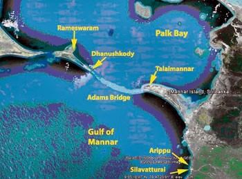
  • Other than these two groups there are islands in Indo-Gangetic Delta [they are more a part of delta than islands] and between India and Sri Lanka [Remnants of Adams Bridge; formed due to submergence].

Andaman and Nicobar Islands

  • This archipelago is composed of 265 big and small islands [203 Andaman islands + 62 Nicobar Islands][Numbers are just for understanding. You need not remember trivial facts].
  • The Andaman and Nicobar islands extend from 6° 45′ N to 13° 45′ N and from 92° 10′ E to 94° 15′ E for a distance adams bridge - ram setu - islandsof about 590 km.
  • The Andaman islands are divided into three main islands i.e. North, Middle and South.
  • Duncan passage separates Little Andaman from South Andaman.
  • The Great Andaman group of islands in the north is separated by the Ten Degree Channel from the Nicobar group in the south [Prelims 2014].
  • Port Blair, the capital of Andaman Nicobar Islands lies in the South Andaman.
  • Among the Nicobar islands, the Great Nicobar is the largest. It is the southernmost island and is very close to Sumatra island of Indonesia. The Car Nicobar is the northernmost.
  • Most of these islands are made of tertiary sandstone, limestone and shale resting on basic and ultrabasic volcanoes [Similar to Himalayas].
  • THE BARREN AND NARCONDAM ISLANDS, north of Port Blair, are volcanic islands [these are the only active volcanoes in India][There are no active volcanoes in main land India].
  • Some of the islands are fringed with coral reefs. Many of them are covered with thick forests. Most of the islands are mountainous.
  • Saddle peak (737 m) in North Andaman is the highest peak.
Andaman and Nicobar islands - ten degree channel

Lakshadweep Islands

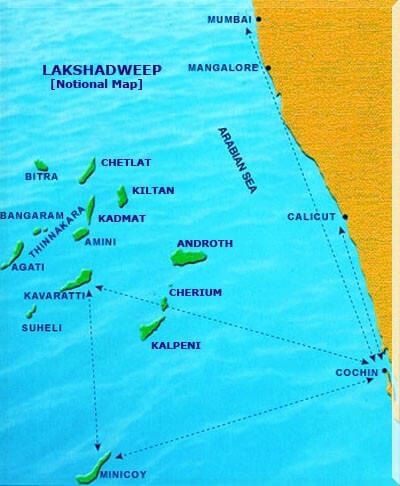
  • In the Arabian Sea, there are three types of islands.
  1. Amindivi Islands (consisting of six main islands of Amini, Keltan, Chetlat, Kadmat, Bitra and Perumul Par). [don’t have to remember all these names]
  2. Laccadive Islands (consisting of five major islands of Androth, Kalpeni, Kavaratti, Pitti and Suheli Par) and
  3. Minicoy Island.
  • At present these islands are collectively known as Lakshadweep.
  • The Lakshadweep Islands are a group of 25 small islands.
  • They are widely scattered about 200-500 km south-west of the Kerala coast.
  • Amendivi Islands are the northern most while the Minicoy island is the southernmost.
  • All are tiny islands of coral origin {Atoll} and are
  • surrounded by fringing reefs.
  • The largest and the most advanced is Lakshadweep Islandsthe Minicoy island with an area of 4.53 sq km.
  • Most of the islands have low elevation and do not rise more than five metre above sea level (Extremely Vulnerable to sea level change).
  • Their topography is flat and relief features such as hills, streams, valleys, etc. are absent.

New Moore Island - india-bangladesh dispute

New Moore Island
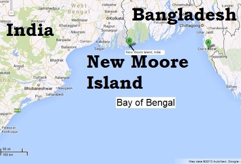
  • It is a small uninhabited offshore sandbar landform {Marine Landforms} in the Bay of Bengal, off the coast of the Ganges-Brahmaputra Delta region.
  • It emerged in the Bay of Bengal in the aftermath of the Bhola cyclone in 1970. It keeps on emerging and disappearing.
  • Although the island was uninhabited and there were no permanent settlements or stations located on it, both India and Bangladesh claimed sovereignty over it because of speculation over the existence of oil and natural gas in the region.
  • The issue of sovereignty was also a part of the larger dispute over the Radcliffe Award methodology of settling the maritim
    e boundary between the two nations
    .

Coastline of India | Coastal Plains of India


Coastline of India (Indian Coastline)

  • India has a coastline of 7516.6 Km [6100 km of mainland coastline + coastline of 1197 Indian islands] touching 13 States and Union Territories (UTs).
  • The straight and regular coastline of India is the result of faulting of the Gondwanaland during the Cretaceous period. {Continental Drift}
  • As such the coast of India does not offer many sites for good natural harbours.
[Indented coastlines of Europe provide good natural harbours whereas African and Indian coastlines are not indented].
  • The Bay of Bengal and the Arabian Sea came into being during the Cretaceous or early Tertiary period after the disintegration of Gondwanaland.
Coastline of India – Indian Coastline

East Coast of India

  • Lies between the Eastern Ghats and the Bay of Bengal.
  • It extends from the Ganga delta to Kanniyakumari.
  • It is marked by deltas of rivers like the Mahanadi, the Godavari, the Krishna and the Cauvery.
  • Chilka lake and the Pulicat lake (lagoon) are the important geographical features of east coast.

Regional Names of The East Coast of India

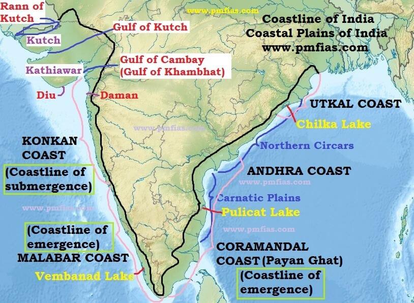
  • In Orissa (Odisha) it is known as Utkal coast.
  • From the southern limit of the Utkal plain, stretch the Andhra coast.
  • In the south of the Andhra plain is the Tamil Nadu coast.
  • The Tamil Nadu coast and parts of Andhra coast together are known as Coramandal Coast or Payan Ghat [False Divi Point in AP (Krishna River Delta) in the north to Kanyakumari in the south.].

West Coast of India

  • The west coast strip extends from the Gulf of Cambay (Gulf of Khambhat) in the north to Cape Comorin (Kanniyakumari).
  • Starting from north to south, it is divided into (i) the Konkan coast, (ii) the Karnataka coast and (iii) the Kerala cost.
  • It is made up of alluvium brought down by the short streams originating from the Western Ghats.
  • It is dotted with a large number of coves (a very small bay), creeks (a narrow, sheltered waterway such as an inlet in a shoreline or channel in a marsh) and a few estuaries. {Marine Landforms}
  • The estuaries, of the Narmada and the Tapi are the major ones.
  • The Kerala coast (Malabar Coast) has some lakes, lagoons and backwaters, the largest being the Vembanad Lake.

Regional Names of The West Coast of India

  • Konkan coast == Maharashtra coast and Goa coast;
  • Malabar Coast == Kerala and Karnataka coast.

Coastlines

Already explained in Marine Landforms. I am discussing here for continuity.
  1. Coastline of Emergence
  2. Coastline of Submergence

Coastlines of Emergence and Submergence

  • Coastline of emergence is formed either by an uplift of the land or by the lowering of the sea level. Coastline of submergence is an exact opposite case.
  • Bars, spits, lagoons, salt marshes, beaches, sea cliffs and arches are the typical features of emergence. {Marine Landforms}
  • The east coast of India, especially its south-eastern part (Tamil Nadu coast), appears to be a coast of emergence.
  • The west coast of India, on the other hand, is both emergent and submergent.
  • The northern portion of the coast is submerged as a result of faulting and the southern portion, that is the Kerala coast, is an example of an emergent coast.
  1. Coramandal coast (Tamil Nadu) ==> Coastline of emergence
  2. Malabar coast (Kerala Coast) ==> Coastline of emergence
  3. Konkan coast (Maharashtra and Goa Coast) ==> Coastline of submergence.

Western Coastal Plains of India

  • Rann of Kachchh in the north to Kanniyakumari in the South.
  • These are narrow plains with an average width of about 65 km.

Kutch and Kathiawar region

  • Kutch and Kathiawar, though an extension of Peninsular plateau (because Kathiawar is made of the Deccan Lava and there are tertiary rocks in the Kutch area), they are still treated as integral part of the Western Coastal Plains as they are now levelled down.
  • The Kutch Peninsula was an island surrounded by seas and lagoons. These seas and lagoons were later filled by sediment brought by the Indus River which used to flow through this area. Lack of rains in recent times has turned it into arid and semi-arid landscape.
  • Salt-soaked plain to the north of Kutch is the Great Rann. Its southern continuation, known as the Little Rann lies on the coast and south-east of Kachchh.
  • The Kathiawar Peninsula lies to the south of the Kachchh. The central part is a highland of Mandav Hills from which small streams radiate in all directions (Radial Drainage). Mt. Girnar (1,117 m) is the highest point and is of volcanic origin.
  • The Gir Range is located in the southern part of the Kathiawar peninsula. It is covered with dense forests and is famous as home of the Gir lion.

Gujarat Plain

  • The Gujarat Plain lies east of Kachchh and Kathiawar and slopes towards the west and south west.
  • Formed by the rivers Narmada, Tapi, Mahi and Sabarmati, the plain includes the southern part of Gujarat and the coastal areas of the Gulf of Khambhat.
  • The eastern part of this plain is fertile enough to support agriculture, but the greater part near the coast is covered by windblown loess (heaps of sand).

Konkan Plain

  • The Konkan Plain south of the Gujarat plain extends from Daman to Goa (50 to 80 km wide).
  • It has some features of marine erosion including cliffs, shoals, reefs and islands in the Arabian Sea.
  • The Thane creek around Mumbai is an important embayment (a recess in a coastline forming a bay) which provides an excellent natural harbour.

Karnataka Coastal Plain

  • Goa to Mangalore.
  • It is a narrow plain with an average width of 30-50 km, the maximum being 70 km near Mangalore.
  • At some places the streams originating in the Western Ghats descend along steep slopes and make waterfalls.
  • The Sharavati while descending over such a steep slope makes an impressive waterfall known as Gersoppa (Jog) Falls which is 271 m high. [Angel falls (979 m) in Venezuela is the highest waterfall on earth. Tugela Falls (948 m) in Drakensberg mountains in South Africa is the second highest.]
  • Marine topography is quite marked on the coast.

Kerala Plain

  • The Kerala Plain also known as the Malabar Plain.
  • Between Mangalore and Kanniyakumari.
  • This is much wider than the Karnataka plain. It is a low lying plain.
  • The existence of lakes, lagoons, backwaters, spits, etc. is a significant characteristic of the Kerala coast.
  • The backwaters, locally known as kayals are the shallow lagoons or inlets of the sea, lying parallel to the coastline.
  • The largest among these is the Vembanad Lake which is about 75 km long and 5-10 km wide and gives rise to a 55 km long spit {Marine Landforms}.

Eastern Coastal Plains of India

  • Extending from the Subarnarekha river along the West Bengal-Odisha border to Kanniyakumari.
  • A major part of the plains is formed as a result of the alluvial fillings of the littoral zone (relating to or on the shore of the sea or a lake) by the rivers Mahanadi, Godavari, Krishna and Cauvery comprising some of the largest deltas.
  • In contrast to the West Coastal Plains, these are extensive plains with an average width of 120 km.
  • This plain is known as the Northern Circars between the Mahanadi and the Krishna rivers and Carnatic between the Krishna and the Cauvery rivers.

Utkal Plain

  • The Utkal Plain comprises coastal areas of Odisha.
  • It includes the Mahanadi delta.
  • The most prominent physiographic feature of this plain is the Chilka Lake.
  • It is the biggest lake in the country and its area varies between 780 sq km in winter to 1,144 sq km in the monsoon months.
  • South of Chilka Lake, low hills dot the plain.

Andhra Plain

  • South of the Utkal Plain and extends upto Pulicat Lake. This lake has been barred by a long sand spit known as Sriharikota Island (ISRO launch facility).
  • The most significant feature of this plain is the delta formation by the rivers Godavari and Krishna.
  • The two deltas have merged with each other and formed a single physiographic unit.
  • The combined delta has advanced by about 35 km towards the sea during the recent years. This is clear from the present location of the Kolleru Lake which was once a lagoon at the shore but now lies far inland {Coastline of Emergence}.
  • This part of the plain has a straight coast and badly lacks good harbours with the exception of Vishakhapatnam and Machilipatnam.

Tamil Nadu Plain

  • The Tamil Nadu Plain stretches for 675 km from Pulicat lake to Kanniyakumari along the coast of Tamil Nadu. Its average width is 100 km.
  • The most important feature of this plain is the Cauvery delta where the plain is 130 km wide.
  • The fertile soil and large scale irrigation facilities have made the Cauvery delta the granary of South India.

Significance of the Coastal Plains

  • Large parts of the coastal plains of India are covered by fertile soils on which different crops are grown. Rice is the main crop of these areas.
  • Coconut trees grow all along the coast.
  • The entire length of the coast is dotted with big and small ports which help in carrying out trade.
  • The sedimentary rocks of these plains are said to contain large deposits of mineral oil (KG Basin).
  • The sands of Kerala coast have large quantity of MONAZITE which is used for nuclear power.
  • Fishing is an important occupation of the people living in the coastal areas.
  • Low lying areas of Gujarat are famous for producing salt.
  • Kerala backwaters are important tourist destinations.
  • Goa provides good beaches. This is also an important tourist destination
    .

Hills of Peninsular India: Aravalis, Vindhyas, Satpuras, Western & Eastern Ghats


Hill Ranges of the Peninsular Plateau

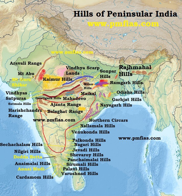
  • Most of the hills in the peninsular region are of the relict type (residual hills).
  • They are the remnants of the hills and horsts formed many million years ago (horst: uplifted block; graben: subsided block).
  • The plateaus of the Peninsular region are separated from one another by these hill ranges and various river valleys.
Hills of India - Aravalis-Vindhyas-Satpuras-kaimur-rajhmahal hills

Aravali Range

  • They are aligned in north-east to south-west direction.
  • They run for about 800 km between Delhi and Palanpur in Gujarat.
  • They are one of the oldest (very old) fold mountains of the world and the oldest in India. {Fold Mountains – Block Mountains}
  • After its formation in Archaean Era (several 100 million years ago), its summits were nourishing glaciers and several summits were probably higher than the present day Himalayas.
  • Now they are relict (remnants after severe weathering and erosion since millions of years) of the world’s oldest mountain formed as a result of folding (Archaean Era).
  • They continue up to Hariddwar buried under the alluvium of Ganga Plains.
  • The range is conspicuous in Rajasthan (continuous range south of Ajmer where it rises to 900 m.) but becomes less distinct in Haryana and Delhi (characterized by a chain of detached and discontinuous ridges beyond Ajmer).
  • According to some geographers, one Branch of the Aravalis extends to the Lakshadweep Archipelago through the Gulf of Khambhat and the other into Andhra Pradesh and Karnataka.
  • It’s general elevation is only 400-600 m, with few hills well above 1,000 m.
  • At the south-west extremity the range rises to over 1,000 m. Here Mt. Abu (1,158 m), a small hilly block, is separated from the main range by the valley of the BanasGuru Sikhar (1,722 m), the highest peak, is situated in Mt. Abu.
  • Pipli Ghat, Dewair and Desuri passes allow movement by roads and railways.

Vindhyan Range

  • The Vindhyan Range, overlooking (have a view of from above) the Narmada valley, rises as an escarpment (a long, steep slope at the edge of a plateau or separating areas of land at different heights) flanking (neighboring on one side) the northern edge of the Narmada-Son Trough (the rift through which the Narmada river flows)(trough is opposite of ridge. It is a narrow depression).
  • It runs more or less parallel to the Narmada Valley in an east-west direction from Jobat in Gujarat to Sasaram in Bihar for a distance of over 1,200 km.
  • The general elevation of the Vindhyan Range is 300 to 650 m.
  • Most parts of the Vindhayan Range are composed of horizontally bedded sedimentary rocks of ancient age. {Rock System}
  • The Vindhyas are continued eastwards as the Bharner and Kaimur hills.
  • This range acts as a watershed between the Ganga system and the river systems of south India.
  • The rivers Chambal, Betwa and Ken rise within 30 km of the Narmada.

Satpura Range

  • Satpura range is a series of seven mountains (‘Sat’ = seven and ‘pura’ = mountains)
  • It runs in an east-west direction south of the Vindhyas and in between the Narmada and the Tapi, roughly parallel to these rivers.
  • It stretches for a distance of about 900 km.
  • Parts of the Satpuras have been folded and upheaved. They are regarded as structural uplift or ‘horst’.
  • Dhupgarh (1,350 m) near Pachmarhi on Mahadev Hills is the highest peak.
  • Amarkantak (1,127 m) is another important peak.

Western Ghats (or The Sahyadris)

  • They form the western edge of the Deccan tableland.
  • Run from the Tapi valley (21° N latitude) to a little north of Kanniyakumari (11° N latitude) for a distance of 1,600 km.
  • The Western Ghats are steep-sided, terraced, flat-topped hills presenting a stepped topography facing the Arabian Sea coast.
  • This is due to the horizontally bedded lavas, which on weathering, have given a characteristic ‘landing stair aspect’ to the relief of this mountain chain.
  • The Western Ghats abruptly rise as a sheer wall to an average elevation of 1,000 m from the Western Coastal Plain.
  • But they slope gently on their eastern flank and hardly appear to be a mountain when viewed from the Deccan tableland.
  • South of Malabar, the Nilgiris, Anamalai, etc. present quite different landscape due to the difference in geological structure.

The northern section

  • The northern section of the Ghats from Tapi valley to a little north of Goa is made of horizontal sheets of Deccan lavas (Deccan Traps).
  • The average height of this section of the Ghats is 1,200 m above mean sea level, but some peaks attain more heights.
  • Kalasubai (1,646 m) near Igatpuri, Salher (1,567 m) about 90 km north of Nashik, Mahabaleshwar (1,438 m) and Harishchandragarh (1,424 m) are important peaks.
  • Thal ghat and Bhor ghat are important passes which provide passage by road and rail between the Konkan Plains in the west and the Deccan Plateau in the east.
[Konkan coast == Maharashtra coast and Goa coast;
Malabar Coast == Kerala and Karnataka coast]

The Middle Sahyadri

  • The Middle Sahyadri runs from 16°N latitude upto Nilgiri hills.
  • This part is made of granites and gneisses.
  • This area is covered with dense forests.
  • The western scarp is considerably dissected by headward erosion of the west flowing streams.
  • The average height is 1200 m but many peaks exceed 1500 m.
  • The Vavul Mala (2,339 m), the Kudremukh (1,892 m) and Pashpagiri (1,714 m) are important peaks.
  • The Nilgiri Hills which join the Sahyadris near the trijunction of Karnataka, Kerala and TN, rise abruptly to over 2,000 m.
  • They mark the junction of the Western Ghats with Eastern Ghats.
  • Doda Betta (2,637 m) and Makurti (2,554 m) are important peaks of this area.

The southern section

  • The southern part of the Western Ghats is separated from the main Sahyadri range by Pal ghat Gap [Palakkad Gap].
  • The high ranges terminate abruptly on either side of this gap.
  • Pal ghat Gap it is a rift valley. This gap is used by a number of roads and railway lines to connect the plains of Tamil Nadu with the coastal plain of Kerala.
  • It is through this gap that moist-bearing clouds of the south-west monsoon can penetrate some distance inland, bringing rain to Mysore region.
  • South of the Pal ghat Gap there is an intricate system of steep and rugged slopes on both the eastern and western sides of the Ghats.
  • Anai Mudi (2,695 m) is the highest peak in the whole of southern India.
  • Three ranges radiate in different directions from Anai Mudi. These ranges are the Anaimalai (1800-2000 m) to the north, the Palani (900-1,200 m) to the north-east and the Cardamom Hills or the Ealaimalai to the south.

Eastern Ghats

  • Eastern Ghats run almost parallel to the east coast of India leaving broad plains between their base and the coast.
  • It is a chain of highly broken and detached hills starting from the Mahanadi in Odisha to the Vagai in Tamil Nadu. They almost disappear between the Godavari and the Krishna.
  • They neither have structural unity nor physiographic continuity. Therefore these hill groups are generally treated as independent units.
  • It is only in the northern part, between the Mahanadi and the Godavari that the Eastern Ghats exhibit true mountain character. This part comprises the Maliya and the Madugula Konda ranges.
  • The peaks and ridges of the Maliya range have a general elevation of 900-1,200 m and Mahendra Giri (1,501 m) is the tallest peak here.
  • The Madugula Konda range has higher elevations ranging from 1,100 m and 1,400 m with several peaks exceeding 1,600 m. Jindhagada Peak (1690 m) in Araku Valley Arma Konda (1,680 m), Gali Konda (1,643 m) and Sinkram Gutta (1,620 m) are important peaks.
  • Between the Godavari and the Krishna rivers, the Eastern Ghats lose their hilly character and are occupied by Gondwana formations (KG Basin is here).
  • The Eastern Ghats reappear as more or less a continuous hill range in Cuddapah and Kurnool districts of Andhra Pradesh where they are called as Nallamalai Range [Naxalite hideout in AP] with general elevation of 600-850 m.
  • The southern part of this range is called the Palkodna range.
  • To the south, the hills and plateaus attain very low altitudes; only Javadi Hills and the Shevroy-Kalrayan Hills form two distinct features of 1,000 m elevation.
  • The Biligiri Rangan Hills in Karnataka (at its border with Tamil Nadu) attain a height of 1,279 m.
  • Further south, the Eastern Ghats merge with the Western Ghats.

Significance of the Peninsular Plateau

  • There are huge deposits of iron, manganese. copper, bauxite, chromium, mica, gold, etc.
  • 98 per cent of the Gondwana coal deposits of India are found in the Peninsular Plateau.
  • Besides there are large reserves of slate, shale, sandstones, marbles, etc.
  • A large part of north-west plateau is covered with fertile black lava soil which is extremely useful for growing cotton.
  • Some hilly regions in south India are suitable for the cultivation of plantation crops like tea, coffee, rubber, etc..
  • Some low lying areas of the plateau are suitable for growing rice.
  • The highlands of the plateau are covered with different types of forests which provide a large variety of forest products.
  • The rivers originating in the Western Ghats offer great opportunity for developing hydroelectricity and providing irrigation facilities to the agricultural crops.
  • The plateau is also known for its hill resorts such as Udagamangalam (Ooty), Panchmarhi, Kodaikanal, Mahabaleshwar, Khandala, Matheron, Mount Abu, etc
    .