Hills of Peninsular India: Aravalis, Vindhyas, Satpuras, Western & Eastern Ghats
Table of Contents
Hill Ranges of the Peninsular Plateau
- Most of the hills in the peninsular region are of the relict type (residual hills).
- They are the remnants of the hills and horsts formed many million years ago (horst: uplifted block; graben: subsided block).
- The plateaus of the Peninsular region are separated from one another by these hill ranges and various river valleys.
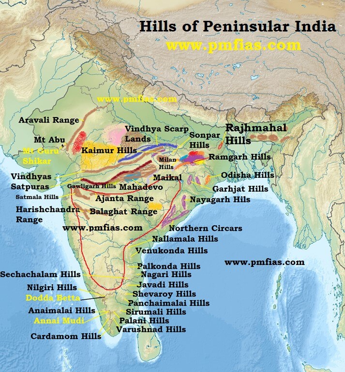
Aravali Range
- They are aligned in north-east to south-west direction.
- They run for about 800 km between Delhi and Palanpur in Gujarat.
- They are one of the oldest (very old) fold mountains of the world and the oldest in India. {Fold Mountains – Block Mountains}
- After its formation in Archaean Era (several 100 million years ago), its summits were nourishing glaciers and several summits were probably higher than the present day Himalayas.
- Now they are relict (remnants after severe weathering and erosion since millions of years) of the world’s oldest mountain formed as a result of folding (Archaean Era).
- They continue up to Hariddwar buried under the alluvium of Ganga Plains.
- The range is conspicuous in Rajasthan (continuous range south of Ajmer where it rises to 900 m.) but becomes less distinct in Haryana and Delhi (characterized by a chain of detached and discontinuous ridges beyond Ajmer).
- According to some geographers, one Branch of the Aravalis extends to the Lakshadweep Archipelago through the Gulf of Khambhat and the other into Andhra Pradesh and Karnataka.
- It’s general elevation is only 400-600 m, with few hills well above 1,000 m.
- At the south-west extremity the range rises to over 1,000 m. Here Mt. Abu (1,158 m), a small hilly block, is separated from the main range by the valley of the Banas. Guru Sikhar (1,722 m), the highest peak, is situated in Mt. Abu.
- Pipli Ghat, Dewair and Desuri passes allow movement by roads and railways.
Vindhyan Range
- The Vindhyan Range, overlooking (have a view of from above) the Narmada valley, rises as an escarpment (a long, steep slope at the edge of a plateau or separating areas of land at different heights) flanking (neighboring on one side) the northern edge of the Narmada-Son Trough (the rift through which the Narmada river flows)(trough is opposite of ridge. It is a narrow depression).
- It runs more or less parallel to the Narmada Valley in an east-west direction from Jobat in Gujarat to Sasaram in Bihar for a distance of over 1,200 km.
- The general elevation of the Vindhyan Range is 300 to 650 m.
- Most parts of the Vindhayan Range are composed of horizontally bedded sedimentary rocks of ancient age. {Rock System}
- The Vindhyas are continued eastwards as the Bharner and Kaimur hills.
- This range acts as a watershed between the Ganga system and the river systems of south India.
- The rivers Chambal, Betwa and Ken rise within 30 km of the Narmada.
Satpura Range
- Satpura range is a series of seven mountains (‘Sat’ = seven and ‘pura’ = mountains)
- It runs in an east-west direction south of the Vindhyas and in between the Narmada and the Tapi, roughly parallel to these rivers.
- It stretches for a distance of about 900 km.
- Parts of the Satpuras have been folded and upheaved. They are regarded as structural uplift or ‘horst’.
- Dhupgarh (1,350 m) near Pachmarhi on Mahadev Hills is the highest peak.
- Amarkantak (1,127 m) is another important peak.
Western Ghats (or The Sahyadris)
- They form the western edge of the Deccan tableland.
- Run from the Tapi valley (21° N latitude) to a little north of Kanniyakumari (11° N latitude) for a distance of 1,600 km.
- The Western Ghats are steep-sided, terraced, flat-topped hills presenting a stepped topography facing the Arabian Sea coast.
- This is due to the horizontally bedded lavas, which on weathering, have given a characteristic ‘landing stair aspect’ to the relief of this mountain chain.
- The Western Ghats abruptly rise as a sheer wall to an average elevation of 1,000 m from the Western Coastal Plain.
- But they slope gently on their eastern flank and hardly appear to be a mountain when viewed from the Deccan tableland.
- South of Malabar, the Nilgiris, Anamalai, etc. present quite different landscape due to the difference in geological structure.
The northern section
- The northern section of the Ghats from Tapi valley to a little north of Goa is made of horizontal sheets of Deccan lavas (Deccan Traps).
- The average height of this section of the Ghats is 1,200 m above mean sea level, but some peaks attain more heights.
- Kalasubai (1,646 m) near Igatpuri, Salher (1,567 m) about 90 km north of Nashik, Mahabaleshwar (1,438 m) and Harishchandragarh (1,424 m) are important peaks.
- Thal ghat and Bhor ghat are important passes which provide passage by road and rail between the Konkan Plains in the west and the Deccan Plateau in the east.
[Konkan coast == Maharashtra coast and Goa coast;
Malabar Coast == Kerala and Karnataka coast]
The Middle Sahyadri
- The Middle Sahyadri runs from 16°N latitude upto Nilgiri hills.
- This part is made of granites and gneisses.
- This area is covered with dense forests.
- The western scarp is considerably dissected by headward erosion of the west flowing streams.
- The average height is 1200 m but many peaks exceed 1500 m.
- The Vavul Mala (2,339 m), the Kudremukh (1,892 m) and Pashpagiri (1,714 m) are important peaks.
- The Nilgiri Hills which join the Sahyadris near the trijunction of Karnataka, Kerala and TN, rise abruptly to over 2,000 m.
- They mark the junction of the Western Ghats with Eastern Ghats.
- Doda Betta (2,637 m) and Makurti (2,554 m) are important peaks of this area.
The southern section
- The southern part of the Western Ghats is separated from the main Sahyadri range by Pal ghat Gap [Palakkad Gap].
- The high ranges terminate abruptly on either side of this gap.
- Pal ghat Gap it is a rift valley. This gap is used by a number of roads and railway lines to connect the plains of Tamil Nadu with the coastal plain of Kerala.
- It is through this gap that moist-bearing clouds of the south-west monsoon can penetrate some distance inland, bringing rain to Mysore region.
- South of the Pal ghat Gap there is an intricate system of steep and rugged slopes on both the eastern and western sides of the Ghats.
- Anai Mudi (2,695 m) is the highest peak in the whole of southern India.
- Three ranges radiate in different directions from Anai Mudi. These ranges are the Anaimalai (1800-2000 m) to the north, the Palani (900-1,200 m) to the north-east and the Cardamom Hills or the Ealaimalai to the south.
Eastern Ghats
- Eastern Ghats run almost parallel to the east coast of India leaving broad plains between their base and the coast.
- It is a chain of highly broken and detached hills starting from the Mahanadi in Odisha to the Vagai in Tamil Nadu. They almost disappear between the Godavari and the Krishna.
- They neither have structural unity nor physiographic continuity. Therefore these hill groups are generally treated as independent units.
- It is only in the northern part, between the Mahanadi and the Godavari that the Eastern Ghats exhibit true mountain character. This part comprises the Maliya and the Madugula Konda ranges.
- The peaks and ridges of the Maliya range have a general elevation of 900-1,200 m and Mahendra Giri (1,501 m) is the tallest peak here.
- The Madugula Konda range has higher elevations ranging from 1,100 m and 1,400 m with several peaks exceeding 1,600 m. Jindhagada Peak (1690 m) in Araku Valley Arma Konda (1,680 m), Gali Konda (1,643 m) and Sinkram Gutta (1,620 m) are important peaks.
- Between the Godavari and the Krishna rivers, the Eastern Ghats lose their hilly character and are occupied by Gondwana formations (KG Basin is here).
- The Eastern Ghats reappear as more or less a continuous hill range in Cuddapah and Kurnool districts of Andhra Pradesh where they are called as Nallamalai Range [Naxalite hideout in AP] with general elevation of 600-850 m.
- The southern part of this range is called the Palkodna range.
- To the south, the hills and plateaus attain very low altitudes; only Javadi Hills and the Shevroy-Kalrayan Hills form two distinct features of 1,000 m elevation.
- The Biligiri Rangan Hills in Karnataka (at its border with Tamil Nadu) attain a height of 1,279 m.
- Further south, the Eastern Ghats merge with the Western Ghats.
Significance of the Peninsular Plateau
- There are huge deposits of iron, manganese. copper, bauxite, chromium, mica, gold, etc.
- 98 per cent of the Gondwana coal deposits of India are found in the Peninsular Plateau.
- Besides there are large reserves of slate, shale, sandstones, marbles, etc.
- A large part of north-west plateau is covered with fertile black lava soil which is extremely useful for growing cotton.
- Some hilly regions in south India are suitable for the cultivation of plantation crops like tea, coffee, rubber, etc..
- Some low lying areas of the plateau are suitable for growing rice.
- The highlands of the plateau are covered with different types of forests which provide a large variety of forest products.
- The rivers originating in the Western Ghats offer great opportunity for developing hydroelectricity and providing irrigation facilities to the agricultural crops.
- The plateau is also known for its hill resorts such as Udagamangalam (Ooty), Panchmarhi, Kodaikanal, Mahabaleshwar, Khandala, Matheron, Mount Abu, etc
.
No comments:
Post a Comment