Himalayas: Glaciers, Valleys & Snowline
Table of Contents
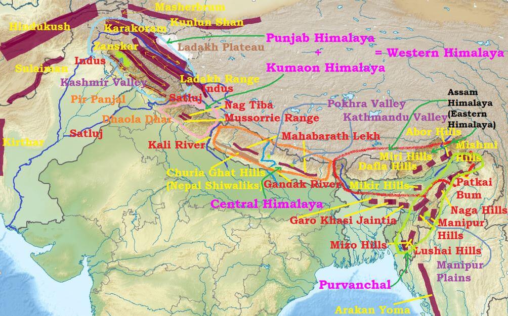
Important Valleys in Himalayas
The most important valleys in the Himalayan region are
- the valley of Kashmir and the Karewas (),
- the Kangra and Kulu valley in Himachal Pradesh;
- the Dun valley (Doon valley, Dehradun valley); the Bhagirathi valley (near Gangotri) and the Mandakini valley (near Kedarnath) in Uttarakhand and
- the Kathmandu valley in Nepal.
Karewas
- Karewas are lacustrine deposits [deposits in lake] in the Valley of Kashmir and in Bhadarwah Valley of the Jammu Division.
- These are the flat topped mounds that border the Kashmir Valley on all sides.
- They are characterized with fossils of mammals and at places by peat.
Formation
- During the Pleistocene Period (1 million years ago), the entire Valley of Kashmir was under water.
- Subsequently, due to endogenetic forces, the Baramullah Gorge was created and the lake was drained through this gorge.
- The deposits left in the process are known as karewas.
- The thickness of karewas is about 1400 m.
- In fact, the karewas have been elevated, dissected and removed by subaerial denudation as well as by the Jhelum river giving them the present position.
Economic Significance
- The karewas are mainly devoted to the cultivation of saffron, almond, walnut, apple and orchards.
- The karewas, devoted to saffron cultivation are fetching good income to the growers.
Snow in Himalayas – Snowline
- In Eastern Himalayas and Kumaon Himalays the snowline is around 3,500 m above sea level whereas in western Himalays snowline is about 2,500 m above sea level.
- This difference in snowline is partly due to the increase in latitude from 28° N in Kanchenjunga to 36° N in the Karakoram.
- But the major factor is precipitation. Precipitation in western Himalayas is comparatively low and occurs mostly as snowfall where as in eastern Himalayas the precipitation is greater and occurs mostly in the form of rain.
- In the Great Himalayan ranges, the snow line is at lower elevation on the southern slopes than on the northern slopes because the southern slopes are steeper and receive more precipitation as compared to the northern slopes.
Glaciers in Himalayas
- There are about 15,000 glaciers in the Himalayas.
- Total area of Himalayas is about five lakh square kilometres (Area of India is nearly 32 lakh sq km). About 33,000 sq km area is covered by snow.
- The snow line (the lowest level of perpetual snow) varies in different parts of the Himalayas depending upon latitude, amount of precipitation and local topography.
Glaciers of the Karakoram Range
- Maximum development of glaciers occurs in the Karakoram range.
- Some of the largest glaciers outside the polar and sub-polar regions are found in this range. The southern side of this range has many gigantic glaciers.
- The 75 km long Siachen Glacier in Nubra valley has the distinction of being the largest glacier outside the polar and the sub-polar regions.
- The second largest is the 74 km long Fedchenko Glacier (Pamirs)
- Third largest is the Hispar Glacier. It is 62 km long and occupies a tributary of the Hunza River.
Glaciers of the Pir Panjal Range
- The glaciers of the Pir Panjal Range are less numerous and smaller in size as compared to those of the Karakoram Range.
- The longest Sonapani Glacier in the Chandra Valley of Lahul and Spiti region is only 15 km long.
Glaciers of the Kumaon-Garhwal Region
- In the Kumaon-Garhwal region of the Himalayas, the largest is the 30 km long Gangotri Glacier which is the source of the holy Ganga.
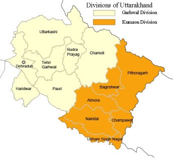
Garhwal Region
- Lying in the Himalayas, it is bounded on the north by Tibet, on the east by Kumaon region, on the south by Uttar Pradesh state, and on the northwest by Himachal Pradesh state.
- It includes the districts of Chamoli, Dehradun, Haridwar, Pauri Garhwal, Rudraprayag, Tehri Garhwal, and Uttarkashi.
Glaciers of Central Nepal
- Zemu and the Kanchenjunga glaciers are the major ones.
Significance of the Himalayas
Influence on Indian Climate
- They intercept the summer monsoons coming from the Bay of Bengal and Arabian Sea causing precipitation in the entire Ganga Plains, North-Eastern Hills.
- They direct the monsoon winds towards north-western India (Punjab, Haryana etc.. But these regions receive most of the rainfall due to Western Disturbances coming from the Mediterranean regions).
- They protect northern-plains from the cold continental air masses of central Asia.
- The Himalayas influence the path of Sub-tropical Jet stream flowing in the region. They split the jet stream and this split jet stream plays an important role in bring monsoons to India.
- Had there been no Himalayas, the whole of India would have been a desert and its winters would have been very severe. [Mechanism of monsoons will be explained in detail later]
Defense
- The Himalayas are a natural defense barrier.
- But the Chinese aggression on India in 1962 has reduced the defense significance of the Himalayas.
Source of Rivers
- Rivers that feed nearly half a billion population of India originate in Himalayas. [we will study this in detail later in drainage system]
- All the rivers are perennial supplying water year round.
Fertile Soil
- The swift flowing rivers from Himalayas bring enormous amount of silt (alluvium) which constantly enrich the Ganaga and Bramhaputra plains.
Hydroelectricity
- Due to its natural topography and swift flowing perennial rivers, the Himalayan region offers several natural sites with great hydroelectric power generation potential.
- Many hydroelectric power plants have already been constructed.
- But all this comes at a great environmental costs.
Forest Wealth
- The Himalayan host rich coniferous and evergreen forests. Lower levels have tropical evergreen forests and higher levels have Alpine vegetation (Coniferous).
- The Himalayan forests provide fuel wood and a large variety of timber for industries.
- Himalayan forests host wide variety of medicinal plants.
- Several patches are covered with grass offering rich pastures for grazing animals.
Agriculture
- Due to rugged and sloped terrain, the Himalayas are not potential agricultural sites.
- Some slopes are terraced for cultivation. Rice is the main crop on the terraced slopes. The other crops are wheat, maize, potatoes, etc.
- Tea is a unique crop which can be grown only on the Shiwalik hill slopes in the region.
- Fruit cultivation is a major occupation. A wide variety of fruits such as apples, pears, grapes, mulberry, walnut, cherries, peaches, apricot, etc. are also grown in the Himalayan region.
Tourism
- Himalayan ranges have a large number of tourist spots.
- The hilly areas in the Himalayas are not affected by hot winds like loo. Hence they offer cool and comfortable climate.
- The increasing popularity of winter sports has increased the rush of tourists in winters.
- Srinagar, Dalhousie, Dharamshala, Chamba, Shimla, Kulu, Manali, Mussoorie, Nainital, Ranikhet, Almora, Darjeeling, Mirik, Gangtok, etc. are important tourist centres in the Himalayas.
Cultural Tourism
- Himalayas host many Hindu and Buddist shrines.
- Kailas, Amarnath, Badrinath, Kedarnath, Vaishnu Devi, Jwalaji, Uttarkashi, Gangotri, Yamunotri, etc. are important places of pilgrimage.
Mineral Resources in Himalayas
- Geosynclinical deposits in tertiary rocks are regions of potential coal and oil reserves.
- Coal is found in Kashmir, Copper, lead, zinc, gold, silver, limestone, semi-precious and precious stones occur at some places in the Himalayas.
- But the exploitation of these resources require advanced technologies which are not yet available.
- Also, disturbing such a fragile environment leads to more pain than gain (present hydroelectric power projects have already proved this)
.
No comments:
Post a Comment